[Report 1911] / Medical Officer of Health, Bury County Borough.
- Bury (Greater Manchester, England). County Borough Council.
- Date:
- 1911
Licence: Attribution 4.0 International (CC BY 4.0)
Credit: [Report 1911] / Medical Officer of Health, Bury County Borough. Source: Wellcome Collection.
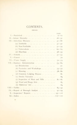
9/126 (page 9)
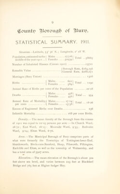
![glounfi? IBoroxtql) of STATISTICAL SU/A/AARY. 1911. Situation—Latitude, 530 36' N. ; Longitude, 20 18' W. Population,estimated to the f Males 27726) ^ota| q866q middleofthe year 1911... \ Females 30939) ‘5 5 Number of Inhabited Houses (Census 191 t) 13721 Rateable Value j Borough Rate, £283,756 (General Rate, £288,071 Marriages (Bury Union) 1308 , Males 601 r-p , 1 B,rths 1 Females 589I Fotal - ”9° Annual Rate of Births per 1000 of the Population 20*28 Deaths Males 478) Females 476] Total 954 Annual Rate of Mortality f Males 17 *24) , remales x5• 38j Excess of Registered Births over Deaths 236 Infantile Mortality 168 per 1000 Births. Density.—The mean density of the Borough from the census of 1911 was equal to 10*05 persons per acre :—In Church Ward, 26*72; East Ward, 16*15 : Moorside Ward, 9*33; Redvales Ward, 9'Q4; Elton Ward, 6*76. Area.—The Municipal Borough of Bury comprises parts of what were formerly the Townships of Tottington-lower-End, Shuttleworth, Bircle-cum-Bamford, Heap, Pilsworth, Pilkington, Radcliffe and Elton, as well as the township of Walmersley, and has a total area of 5907 acres. Elevation.—The mean elevation of the Borough is about 300 feet above sea level, and varies between 223 feet at Blackford Bridge and 765 feet at Higher Sedger Hey.](https://iiif.wellcomecollection.org/image/b28968426_0009.jp2/full/800%2C/0/default.jpg)