180 results filtered with: Map
- Books
Mappa mundi.
Qiu ZhijieDate: [2019]- Books
Historical atlas of Canada / Geoffrey J. Matthews, cartographer/designer.
Date: 1987- Online
Traveller’s guide : a map of the Ohio and Mississippi Rivers, extending from Pittsburgh to the Gulf of Mexico.
Duff, JosephDate: 1844- Ephemera
Disability : transport ephemera. Box 3.
- Ephemera
Oversize ephemera. EPH+47.
- Books
An encyclopaedia of North and South America, 1786 / [by D. Fenning and J. Collyer] : with an introduction by G.R. Crone.
Daniel FenningDate: [1976]
- Pictures
- Online
American Civil War: the free and slave states, and of the unsettled territory. Wood engraving, 1856.
Date: [1856]Reference: 37933i- Books
Zirkulare, Sitzungsprotokolle etc. betreffend organisatorische Dispositionen des XVI. Internationalen Physiologen-Kongresses.
International Congress of Physiological SciencesDate: [1938?]
- Pictures
- Online
The Earth: map. Engraving, 1782.
Date: [1785]Reference: 677709i
- Pictures
- Online
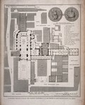
Botanic Gardens, Oxford: plan of the gardens with details of the gateway and greenhouses. Etching, 1707, after D. Loggan.
David LogganDate: 1707Reference: 21214i- Books
The Peak district / Duphar Laboratories.
Date: 1970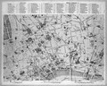
- Digital Images
- Online
Plan of London, Medical socities and hospitals.
- Pictures
- Online
St Bartholomew's Priory, London: the ground plan, with a key, scale, and depiction of the conventual seals. Engraving by T. Bourne, 1821.
Date: 25 March 1821Reference: 24064i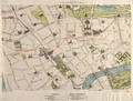
- Pictures
- Online
A map of London: showing sites of medical interest in Chelsea and Kensington. Coloured lithograph, 1913.
Date: 1913Reference: 40394i
- Pictures
- Online
A map of Witwatersrand goldfield, South Africa, showing properties of the Rand Mines Limited. Chromolithograph after Edward H. V. Melvill.
Melvill, Edward H.V (Edward Harker Vintcent), 1859-1914.Date: [1895]Reference: 29630i
- Pictures
- Online
Map of Captain Cook's voyages. Engraving by W. Palmer after Lieutenant H. Roberts, 1785.
Henry RobertsDate: 1785Reference: 566202i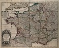
- Pictures
- Online
France: map. Coloured engraving by H. Jaillot, ca. 1710 (?).
Date: [1710?]Reference: 677646i- Books
Yorkshire moors / Duphar Laboratories.
Date: 1971- Books
Beijing li shi yu tu ji = Collection of Beijing historical maps.
Capital Library of ChinaDate: 2005- Books
The A to Z of Restoration London : (the City of London, 1676) / introductory notes by Ralph Hyde ; index compiled by John Fisher and Roger Cline.
Ogilby, John, 1600-1676. Large and accurate map of the City of LondonDate: 1992
- Pictures
- Online
Elevation of the Cape of Good Hope and and map of South Africa. Engraving.
Date: 1745Reference: 576753i- Maps
Allgemeiner ethnographischer Atlas, oder, Atlas der Völker-Kunde : eine Sammlung von neunzehn Karten : ein Versuch / von Dr. Heinrich Berghaus.
Heinrich BerghausDate: 1852- Pictures
Map of China. Colour lithograph, 1973.
Date: [January 1973]Reference: 778012i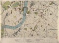
- Pictures
- Online
A map of London: showing sites of medical interest in Lambeth, Pimlico, Southwark and Westminster. Coloured lithograph, 1913.
Date: 1913Reference: 40389i- Pictures
Cambridge: map of the city with a key, a view from the fields with a numerical key, Great St Mary's church. Line engraving.
Reference: 16345i