33 results filtered with: Surveying
- Pictures
Surveying: a surveyor's level, disassembled (above) and assembled (below). Engraving by H. Mutlow, 1810.
Date: Sept.r 1st 1810Reference: 46698i- Archives and manuscripts
Zapogha, Nicolo
Zapogha, NicoloDate: 1749Reference: MS.5115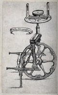
- Pictures
- Online
Measurement: a pedometer. Engraving, [1661?].
Date: 1661Reference: 46693i
- Pictures
- Online
Mathematics: various surveying instruments. Engraving by Benard.
Reference: 47858i- Books
Méthode de lever les plans et les cartes de terre et de mer ... / par feu M. Ozanam ouvrage entièrement refondu et augmenté par M. Audierne / [Jacques Ozanam].
Jacques OzanamDate: 1781
- Books
- Online
Del modo di misvrare, le distantie, le superficie, i corpi, le piante, le prouincie, le prospettiue, e tutte le altre cose terrene, che possono occorrere a gli huomini, secondo le uere regole d'Euclide, e de gli altri piu lodati scrittori / [Cosimo Bartoli].
Cosimo BartoliDate: 1564
- Pictures
Geology: a long section through mountains, and a volcano, showing strata, and, above, classes of animals. Coloured engraving by J. Fisher after T. Webster and F. Buckland.
Thomas WebsterReference: 46742i
- Pictures
- Online
Surveying: levels and other equipment. Engraving by J.B.P. Tardieu.
Reference: 46697i
- Pictures
- Online
Mathematics: various surveying instruments. Engraving by Benard.
Reference: 47857i- Books
Del modo di misvrare, le distantie, le superficie, i corpi, le piante, le prouincie, le prospettiue, e tutte le altre cose terrene, che possono occorrere a gli huomini, secondo le uere regole d'Euclide, e de gli altri piu lodati scrittori / [Cosimo Bartoli].
Cosimo BartoliDate: 1564- Books
Del modo di misurare le distantie, le superficie, i corpi, le piante, le prouincie, le prospettiue, e tutte le altre cose terrene, che possono occorrere a gli huomini, secondo le uere regole d'Euclide, e de gli altri piu lodati scrittori / [Cosimo Bartoli].
Cosimo BartoliDate: 1589- Archives and manuscripts
Arago, Dominique Francois (1786-1853), French astronomer and politician
Date: c.1814-1848Reference: MS.7039- Books
Descrittione, et uso dell'holometro, per saper misurare tutte le cose, che si possono veder coll'occhio cosi in lunghezza, et larghezza; come in altezza, et profondità ... / ritrovato per Abel Fullone Valletto di Camera del re di Francia.
Foullon, Abel, 1513-1563.Date: 1564
- Archives and manuscripts
- Online
Almanac in Latin and English, in codex form
Date: c 1464Reference: MS.41- Pictures
Mathematics: a sector rule and other mathematical instruments. Engraving.
Reference: 47872i- Books
Del modo di misvrare le distantie : le superficie, i corpi, le piante, le prouincie, le prospettiue, e tutte le altre cose terrene, che possono occorrere à gli huomini, secondo le vere regole d'Euclide, e de gli altri più lodati scrittori / Dedicata all'illvstrissimo, et eccellentissimo signore, il sig. Combi de Medici.
Cosimo BartoliDate: 1614- Books
De agrorum conditionibus, et constitutionibus limitum. Siculi Flacci lib. I : Ivlii Frontini lib. I Aggeni Urbici lib. II Hygeni Gromatici lib. II Variorum auctorum Ordines finitionum. De iugeribus metiundis. Finium regundorum. Lex mamilia. Coloniarum pop. Romani descriptio. Terminorum inscriptiones & formae. De generibus lineamentorum. De mensuris & ponderibus.
Date: 1554
- Pictures
- Online
Louis Lacharme, with a level and with local assistants, clearing a route through dense jungle in Panama for an interoceanic canal. Wood engraving by G. Vuillier.
Date: 1800-1899Reference: 46724i
- Pictures
- Online
An Arabic (?) man singing from a songbook; African or Indian men surveying the land; westerners sowing seed and reaping; smiths hammering iron. Engraving.
Reference: 30052i- Archives and manuscripts
Vom Gründlegen und Feldmesse. Von Erwehlungen der Planeten Aspecten
Date: Late 16th centuryReference: MS.795- Pictures
Surveying: equipment for field surveying, a extending tower. Wood engraving.
Reference: 46723i- Books
Dell'arte del misurare libri due, nel primo de' quali s'insegna a misurare et partir' i campi. Nel secondo a misurar le muraglie, imbottar grani, vini, fieni, et strami; col livellar dell'acque et altre cose necessarie a gli agrimensori / Di M. Girolamo Cataneo.
Cataneo, Girolamo, active 1564.Date: 1584- Books
Precision site surveying and setting-out / [Gordon Tomalin].
Tomalin, Gordon.Date: [1964]
- Pictures
- Online
A man and his assistant holding a rope to survey a field. Woodcut, 15--.
Date: 1500-1599Reference: 578817i
- Pictures
- Online
Geography: comparative heights of mountains in South America. Aquatint, 1818.
Date: 1818Reference: 46888i