87 results filtered with: Topography

- Digital Images
- Online
Zante, new town rebuilt after the earthquake of 1953. From a postcard (Dr. O'Malley).

- Digital Images
- Online
Map of Crimea.

- Digital Images
- Online
Peasant Spa of Krapinske Toplice, Yugoslavia.
- Digital Images
- Online
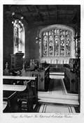
Gray's Inn Chapel.

- Digital Images
- Online
The Emperor of the French battle-field of Solferino.

- Digital Images
- Online
Guillaume Thomas Francois Raynal.
- Digital Images
- Online
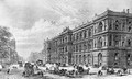
The new Home and Colonial Offices, Westminster, 1875.

- Digital Images
- Online
Diego Ribero's map of the world, 1529.
Diego Ribero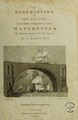
- Books
- Online
A description of the country from thirty to forty miles around Manchester / the materials arranged and the work composed by J. Aikin.
John AikinDate: 1795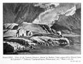
- Archives and manuscripts
- Online
M0012075: Reproduction of an engraving of the view of the Grimsel Hospice, from De Beer's Early Travellers in the Alps, 1930
Date: 1951Reference: WT/D/1/20/1/107/63Part of: Wellcome Trust Corporate Archive
- Digital Images
- Online
Peasant Spa of Krapinske Toplice, Yugoslavia.

- Digital Images
- Online
Smithfield Market.
- Books
- Online
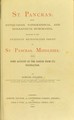
St. Pancras; being antiquarian, topographical, and biographical memoranda : relating to the extensive metropolitan parish of St. Pancras, Middlesex: with some account of the parish from its foundation.
Date: 1870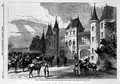
- Digital Images
- Online
War: France and Germany, 1870.

- Digital Images
- Online
Possible site of Vesalius landing on the island.

- Books
- Online
The history, topography and directory of Warwickshire; inclusive of some portions of the ancient histories of Rous, Camden, Speed, and Dugdale, with curious memoirs of the lives of these early writers : a description of the present state of the county with its modern divisions and subdivisions, and their population and valuation; a directory of every town and considerable village in the county; a gazetteer of all the towns, villages, parishes and hamlets, with their distances from the principal market or post towns, and from London; and an itinerary of the direct and cross roads, with a list of the noblemen and gentlemen's seats, illustrated with characteristic etchings and a map of the county.
West, William, 1770-1854.Date: 1830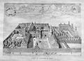
- Archives and manuscripts
- Online
M0012088: Reproduction of a plan of Gonville and Caius College, Cambridge, showing the Gate of Honour, with the caption "View by Loggan (c.1688)" underneath
Date: 1951Reference: WT/D/1/20/1/107/75Part of: Wellcome Trust Corporate Archive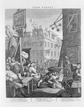
- Digital Images
- Online
Beer Street by William Hogarth
William Hogarth
- Digital Images
- Online
Labour Yard in Bethnel Green. Also Sewing-class.
- Archives and manuscripts
- Online
M0012086: Reproduction of a sketched plan of Kirk O' Field showing the site that later became of the town's college (now known as The University of Edinburgh)
Date: 1951Reference: WT/D/1/20/1/107/73Part of: Wellcome Trust Corporate Archive
- Digital Images
- Online
Ancient Turret, rue de l'Ecole de Medecine.
- Archives and manuscripts
- Online
M0012076: Reproduction of an illustration captioned "St. James's Palace and part of the city of Wesminster taken from the north side of Pall Mall as they appeared about the year 1660"
Date: 1951Reference: WT/D/1/20/1/107/64Part of: Wellcome Trust Corporate Archive
- Digital Images
- Online
Railways in 1800, Great Britain.

- Digital Images
- Online
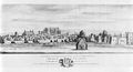
Bradford from North.
- Digital Images
- Online
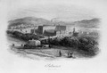
Saltare from the North East of England. Built for the manufacture of Alpaca and Mohair. Opened by Titus Salt in 1853. Planned with admirable arrangement for ensuring the health and comfort of the workpeople, and preventing accidents from the shafting and gearing.