Report of the County Medical Officer upon the sanitary condition of the Goole Union (West Riding portion) / West Riding County Council Sanitary Committee.
- West Riding of Yorkshire (England). County Council
- Date:
- 1901
Licence: Attribution 4.0 International (CC BY 4.0)
Credit: Report of the County Medical Officer upon the sanitary condition of the Goole Union (West Riding portion) / West Riding County Council Sanitary Committee. Source: Wellcome Collection.
6/46 page 3
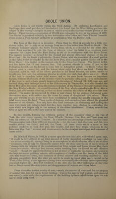
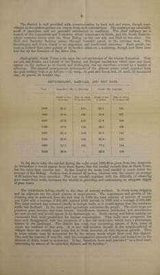
![TABLE I—AREA, POPULATION, RATEABLE VALUE, Etc. Area 1891 • ' Census Figures. Density of Population, 1891. Rate¬ able Elevation (in feet] above Sea Level. Drainage Area. • Acres. Popula¬ tion. Inhab. Houses. Persons per House. 1 ersons per Acre. Value 1900. £ Max. Min. Industries. (1) (2) (3) (4) (5) (6) (7) (8) (9) (10) (11) Urban District:— Goole 1441 15416 3057 5-04 1(P7 67894 20T 8-3 Ouse Shipping, Shipbuilding, Chemical Works Rural Parishes:— Acllingfleet 1848 211 51 4T4 0-11 1524 18-0 3-0 Trent Agriculture Airmyn 3961 539 99 5-44 0T4 9259 15-9 7-3 Aire, Ouse ?) Eastoft 1328 101 14 7-21 0-08 1470 14-4 5-5 Trent ? 5 Fockerby 853 82 17 4-82 0-10 902 14-2 8-4 Trent Goole Fields 4160 311 55 5-65 0-07 5433 21-2 4-3 Ouse Gowdall 1210 237 51 4-65 0-20 2266 28-0 220 Aire >5 Haldenby 1476 80 10 8-00 0-05 1592 17-3 4-2 Trent ?) Hooke 984 560 134 4T8 0-57 1605 16-9 9-7 Ouse 55 Ousefleet 2885 243 45 5-40 0-08 2162 15-0 3-6 Ouse, Trent 55 Pollington 1947 387 97 3-99 0'20 4064 50-0 17-0 Went, Aire 5> Rawcliffe 4512 1730 427 4-05 0-38 14190 18-4 7-6 Aire 55 Reedness 3083 473 115 4-11 0-15 8463 16-0 3-5 Ouse 5 Snaitli and Cowick ... 6018 1596 386 4.-13 0-27 13721 33-0 8-0 Aire, Ouse Swinefleet 2472 1160 281 4-13 0-47 4489 14-1 4-9 Ouse Whitgift 1501 286 69 4-14 0-19 1782 17-0 4-2 Ouse, Trent 55 • Total of Rural Parishes. 38238 1996 1851 4-32 0-21 67922 Goole Union (West Riding portion) 39679 23412 4908 4-77 0-59 135816 From the above table it can be elicited that though the Urban District has a population density on an average of 1\persons to the acre, yet the house density of five persons is less than in five of the Rural Parishes, but the average of the latter is only 43. While the area of the Rural District is twenty-six times larger, it has only half the population of the Urban District, and as regards rateable value both are nearly equal. In only two of the parishes are there less than 1000 acres. TABLE II—GROWTH OF POPULATION IN NINE DECADES, 1801—1891. Pre¬ sent Area. Acres. POPULATION. 1801 1811 1821 1831 1841 1851 1861 1871 1881 1891 (1) (2) (3) (4) (5) (6) (7) (8) (») (10) (U) (12) Urban District;— Goole 1441 ( 7700 10418 15416 Rural Parishes:— l 542 696 813 2321 4071 5119 6437- Goole Fields 4160 — 277 311 Hooke 984 1 520 507 560 Adlingfleet 1848 203 223 256 218 199 226 225 266 195 211 Airmvn 3961 391 451 570 567 593 561 557 534 478 539 Eastoft 1328 78 79 88 82 82 90 90 89 77 101 Fockerby 853 84 86 106 103 92 107 108 88 81 82 Gowdall 1210 218 227 243 260 237 229 223 220 203 237 Haldenby 1476 72 73 81 75 75 64 57 86 91 80 Ousefleet 2885 207 223 253 243 228 227 233 215 210 243 Pollington 1947 378 429 483 482 585 495 501 467 397 387 Rawcliffe 4512 920 1143 1496 1450 1523 1552 1630 1646 1650 1730 Reedness 2725 520 561 683 644 633 663 601 576 494 473 Snaitli and Cowick ... 6018 1397 1399 1739 1813 1737 1759 1763 1863 1730 1596 Swinefleet 2830 632 770 956 1055 1145 1152 1149 1319 1233 1160 Whitgift 1501 263 290 310 310 347 852 315 326 362 286 Goole Union 39679 5905 6650 8077 9623 11547 12596 13889 15915 18403 23412 (West Riding portion)](https://iiif.wellcomecollection.org/image/b30694917_0006.jp2/full/800%2C/0/default.jpg)