A history of the Bristol Royal Infirmary / by G. Munro Smith.
- Smith, George Munro, 1856?-1917.
- Date:
- [1917]
Licence: In copyright
Credit: A history of the Bristol Royal Infirmary / by G. Munro Smith. Source: Wellcome Collection.
36/644 page 14
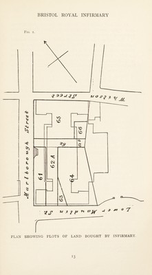
![At the next Committee Meeting on January 21st, 1736-7, when Dean Creswick was again in the Chair, the important question of a site was discussed. “ The Society ” (as it is always called in the early records) hesitated between the “ White Lodge,”1 a building at the bottom of St. Michael’s Hill, near the King David Tavern, the grounds of which were used as a mason’s yard, and two houses in St. James’s Churchyard near Maudlin Lane (now Lower Maudlin Street). A suggestion was also made that some rooms in “ the Mint ” (as St. Peter’s Hospital was then called) should be utilised. It was decided that Dr. Bonython and Mr. Thornhill (repre¬ senting medicine and surgery) should examine the houses in St. James’s, and that Messrs. Morgan Smith, Andrews, Curtis and Champion “ be desired to inform themselves upon what Terms the said Houses may be had,” both reports to be presented at the next meeting. These Sub-Committees reported favourably of “ a Loft,. Warehouse, Cellar and other Buildings and waste ground situate in Maudlin Lane ; ” and “ at a General Meeting held at the Surgeons’ Hall, Mr. Recorder [Serjeant Foster] in the Chair,” it was agreed that Serjeant Foster, John Elbridge, John Andrews, and Mr. Richard Champion “ be desired to accept of a Lease; ” and that these gentlemen, together with Alderman Rich, Thomas Curtis, Paul Fisher, William Thornhill and Dr. Bonython should form a Committee to prepare the house to- receive patients. According to John Townsend (who was elected Surgeon in 1754) these buildings had formerly been used as a brewery. They were situated on the piece of land marked 64 on the plan shown on page 13 (Fig. 1), which is copied by permission of Mr. Noble Pope from old deeds in his office. It covers part of the ground now occupied by the lower end of the south-west wing of the present Infirmary and a portion of the Out-patient Department. Below it, to the south-east, there former!}/ ran a narrow road called Earl Street, and below this were Mr. Scudamore’s house and Whitson Court, both standing in gardens. Farther down still was St. James’s Church and Churchyard. (See Fig. 2.) It has been stated that the first Infirmary was built upon ground which had at one time been used for religious purposes. This is very probable, as St. James’s Priory was situated near 1 This belonged to the Edgar Family, and was built by Sir Thomas Langton in the time of Charles II. It was destroyed in 1829-30, and some small houses were built on the site called “ Mulberry Place,” from a tree which stood in the garden. H](https://iiif.wellcomecollection.org/image/b29930017_0036.jp2/full/800%2C/0/default.jpg)


 No text description is available for this image
 No text description is available for this image
 No text description is available for this image