[Report 1938] / Medical Officer of Health, West Lancashire R.D.C.
- West Lancashire (England). Rural District Council.
- Date:
- 1938
Licence: Attribution 4.0 International (CC BY 4.0)
Credit: [Report 1938] / Medical Officer of Health, West Lancashire R.D.C. Source: Wellcome Collection.
54/138 page 48
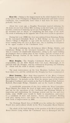
![River Alt.—Owing to the improvement in the tidal channel, the level of the water at the Floodgates at Hightown in flood time and under normal conditions, was considerably lower than it had been for many years, ]:)robably forty-five. About five years ago, a Dragline Excavator started widening the Alt down-stream from Sefton Mill, working on the left bank, and another machine commenced widening up-stream from Hightown. Last autumn, the machines met at Altcar, so completing the first stage of the work. The work of widening on the opposite side of the river is now in operation. During last year (1938) the river was widened from Dunnings Bridge on the Liverpool /Ormskirk Road to Bull Bridge on the road from Aintree Village to Maghull, to cope with the increase in the amount of water coming down the river in flood time, due to building development in the upper reaches of the Catchment Area. The work of widening the Alt between Alder’s Bridge, Kirkby, and Clockhouse Bridge on the Liverpool boundarv, has just commenced. This is a matter of considerable importance, owing to the rapid building development that is taking place in this vicinity, and the erection of the Balloon Barrage Station on the banks of the Alt, between these two points. River Douglas.—The Douglas Catchment Board has taken over responsibility for the Eller Brook from Carr Lane, Burscough, to its junction with the Douglas, and has commenced deepening and widening it. About half the work is alreadv completed. The main watercourses on the Low Meadows, Lathom, have also been taken over, and the outfall into the Douglas has been reconstructed. River Crossens.—More than three-quarters of the River Crossens Catchment Area of 37,906 acres lies within the area of the West Lancashire Rural District. In includes on the West the greater part of the County Borough of Southport and extends on the East to Hundred End, Tarleton, Rufford, Burscough Bridge, Ormskirk, and on the South to Halsall. A considerable proportion of this Area within the West Lancashire Rural District lies below the level of high water mark of Spring tides, and but for the operations of the Catchment and Drainage Boards in improving and maintaining the drainage system and the sea and river banks, some 15,000 acres would be liable to inundation, and revert to a condition of mere and morass. Severe and extensive flooding took place during heavy rain before the Catchment Board commenced their work of improvement in 1933. The Drainage Board Area of 18,039 acres lies within the Catchment Board Area and is almost wholly in the West Lancashire Rural District. The whole of the land drainage of the portion of the West Tamcashire Rural District lying within the Catchment Area i^j discharged into the](https://iiif.wellcomecollection.org/image/b30261648_0054.jp2/full/800%2C/0/default.jpg)