[Report 1937] / Medical Officer of Health, Fareham U.D.C.
- Fareham (England). Urban District Council.
- Date:
- 1937
Licence: Attribution 4.0 International (CC BY 4.0)
Credit: [Report 1937] / Medical Officer of Health, Fareham U.D.C. Source: Wellcome Collection.
6/40 (page 4)
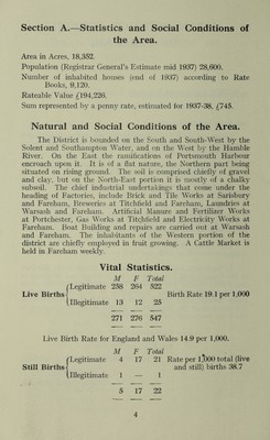
![Section A.—Statistics and Social Conditions of the Area. Area in Acres, 18,352. Population (Registrar General’s Estimate mid 1937) 28,600. Number of inhabited houses (end of 1937) according to Rate Books, 9,120. Rateable Value £194,226. Sum represented by a penny rate, estimated for 1937-38, £745. Natural and Social Conditions of the Area. The District is bounded on the South and South-West by the Solent and Southampton Water, and on the West by the Hamble River. On the East the ramifications of Portsmouth Harbour encroach upon it. It is of a flat nature, the Northern part being situated on rising ground. The soil is comprised chiefly of gravel and clay, but on the North-East portion it is mostly of a chalky subsoil. The chief industrial undertakings that come under the heading of Factories, include Brick and Tile Works at Sarisbury and Fareham, Breweries at Titchfield and Fareham, Laundries at Warsash and Fareham. Artificial Manure and Fertilizer Works at Portchester, Gas Works at Titchfield and Electricity Works at Fareham. Boat Building and repairs are carried out at Warsash and Fareham. The inhabitants of the Western portion of the district are chiefly employed in fruit growing. A Cattle Market is held in Fareham weekly. Vital Statistics. M F Total (Legitimate 258 264 522 Live Births] Birth Rate 19.1 per 1,000 (illegitimate 13 12 25 271 276 547 Live Birth Rate for {Legitimate Illegitimate England and Wales 14.9 per 1,000. M F Total 4 17 21 Rate per 1*000 total (live and still) births 38.7 1 — 1 5 17 22](https://iiif.wellcomecollection.org/image/b2920155x_0006.jp2/full/800%2C/0/default.jpg)