[Report 1919] / Medical Officer of Health, Manchester City.
- Manchester (England). City Council. n 88637066.
- Date:
- 1919
Licence: Attribution 4.0 International (CC BY 4.0)
Credit: [Report 1919] / Medical Officer of Health, Manchester City. Source: Wellcome Collection.
25/307 page 16
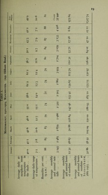
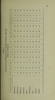
![The suggestion is that the male death-rate is largely of an easily controlled character. Pneumonia is now a notifiable disease, and cases are being investigated. The investigation is in its infancy, and notification so far has been most imperfectly carried out. It is necessary to realise that this disease is going to require an administration comparable with that under I uberculosis, though not so costly. As the work progresses this will become manifest. The approximation of female to male deaths in Manchester is due not merely to improvement in the male death-rate, but also to females not sharing equally in the improvements which have taken place, owing to the heavier share of this work which they have now taken, and are likely to continue to take. It is partly an outcome of the war, and carries considerable potentialities. The materials for a comparison with other localities are not to hand for 1919. and this is, therefore, omitted. Similarly an analysis of the mortalities in age periods is not given in the form of death-rates. The figures are too uncertain, and will continue to be so until a fresh census has been obtained. METEOROLOGY. SOIL, &c. Manchester and Salford lie in a basin in the south-east corner of Lancashire embraced to the north, east, and south by the Pennine Range, and surroundcc by a number of industrial centres whose chief productions are coal, machinery and cotton goods. They are traversed by the Irwcll, the Irk, the Medlock, and a number 0 small brooks, and their suburban districts stretch out to the Mersey. Wfcl rising towards the north, their surface is otherwise flat. The Town Hall, Manchester, is situated in N. Lat. 53' 28' 44 and W. long 2° 14' ]-[■ The mean elevation of the City above ordnance datum is 189 feel the greatest elevation being 348 feet in Blackley and the least 80 feet i Cornbrook Road. The geological strata consist of boulder clay, drift, sands and gravels, ovei lying a series of strata which dip westward from the Pennine Range. Th« are the new red sandstone, the Permian rocks, the-upper middle and low coal measures, and underneath these the millstone grit, Yoredale shale, linn stone and carboniferous limestone. The strata are reached in the reverse order as we descend from the hil about Saddleworth through Oldham ; first the millstone grit, then the lowe then the middle coal measures, and finally the upper coal measures, which 1 at a considerable depth below the surface in Manchester and Salford. A map of the surface geology of Manchester was published in the Manchest 1 iterary and Philosophical Society’s Memoirs, 1847. This shows that a shal 0 section carried from Broughton in Salford to Openshaw in Manchester pass, almost entirely through drift clay.](https://iiif.wellcomecollection.org/image/b29785406_0026.jp2/full/800%2C/0/default.jpg)