On three several hurricanes of the Atlantic, and their relations to the northers of Mexico and Central America, with notices of other storms / by W.C. Redfield.
- William C. Redfield
- Date:
- 1846
Licence: Public Domain Mark
Credit: On three several hurricanes of the Atlantic, and their relations to the northers of Mexico and Central America, with notices of other storms / by W.C. Redfield. Source: Wellcome Collection.
Provider: This material has been provided by the National Library of Medicine (U.S.), through the Medical Heritage Library. The original may be consulted at the National Library of Medicine (U.S.)
52/142
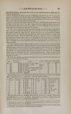
![In an account printed at Key West, it is stated that the unequalled fury of the gale when at its height can scarce be conceived. It swept every thing before it—houses, fences, trees, vessels—and almost every thing in its course was levelled with the earth or borne off with frightful velocity. 39. At Indian Key, off the S. point of Florida, [lat. 24° 47', Ion. 80° 48', about 75 miles L.,] most of the houses remaining there were blown down and all the wharves destroyed. 40. Brig Ventrosa, was lost on the Bimini Islands in the hurricane. [VV. edge of the Bahama Bank, lat. 25° 40', Ion. 79° 12', about 35 miles L.] 41. At Jupiter Inlet, St. Louis Sound and Indian river, on the E. shore of Florida, be- tween lat. 26° 30', and 28°, the gale was severe on the 5th, causing a great influx of the sea. [This part of the coast is 112 to 150 miles L. of the axis line.] 42. At Fort Brooke, head of Tampa Bay, Florida, [lat. 27° 57', Ion. 82° 35', about 300 miles L.,] there was no rain, except light showers on the afternoon of Oct. 2d. The lowest observations of the barometer were made on the evening of the 5th and morning of the 6th, 2979 in. It may have been lower in the night. The daily averages of the barometer and state of the winds, were as follows, viz.—Oct. 1st, bar. 3050, wind, E., 3 ; Oct. 2d, bar. 30-16, winds N. E. and E., 1 and 4 ; 3d, bar. 3006, wind E., 1 ; 4th, bar. 291)4, wind N. E., 1; on the 5th, bar. 2984, wind E., 2,4,6, 4 ;* 6th, bar. 29 88, winds N. E., 3, 2,1; 7th, bar. 30 07, calm. [Fort Brooke is not more advanced in the track of the storm than the island of New Providence, Bahamas; and its deeply embayed position, on the west side of the Florida peninsula, doubtless contributed to its shelter from the force of the gale.] 43.t At Charlotte Harbor, [west coast of Florida, lat. 26° 48', Ion. 82° 5', 228 miles I,., and less advanced in the track than Fort Brooke,] the gale blew from N. E. and was much stronger than at Tampa Bay. Its violence greatly increased, on that coast, as we go S. toward Key West, as I am informed by (apt. Parker ; this being in fact a nearer approx- imation to the center path of the gale. 44.t At Apalachicola, [lat. 29° 43', Ion 85° 05', near 475 miles L. of axis line,] there was no gale ; the winds were moderate from the N. E., with clouds flying somewhat briskly from that quarter. 45a. At St. Augustine, [Fort Marion, E. coast of Florida, lat. 29° 40', Ion. 81° 35', 305 miles LJ Oct. 1, bar. (average) 30 18, winds N., 4 to 8 ; 2d, bar. 30-18, wind E., 6 j 3d, bar. 3007, wind E , 3, 2; 4th, bar. 29 90, wind N. E , 1. On the 5th, bar. 2999, 2982, winds N. E., 3, N., 4, 7, N. E., 8, drizzling rain at 2 p. m. ; violent wind at 10 p. m. equal to 9. [Heaviest of gale in the night.] 6th, bar. 2975, 30 01, winds N. W. 5, 6, N. E. 3, 0 ; 7th, bar. 30-13, wind W. 1, 0. The gale set in brisk a. m. on the 5th. [Distance from the axis line greater than at Tampa Bay, but the position of St. Augustine, on the E. coast, was far more exposed to the gale. The state of the barometer and winds show that both these places were toward the left border of the gale, which in passing onw-ard did not fully extend its force to Savannah and Charleston.] 456. Brig Demarara, at and from Neuvitas, N. side of Cuba, Sept. 28th, fair, light breeze from N. N. E.; 29th, fair, strong breeze from N. N. E.; 30th, begins calm, cloudy and hazy, 8 a. m. light breeze from N. N. W. Put to sea. Noon, lat. 21° 46', Ion. 77° 08'; [Bahama Old Channel;] 1 p. m. wind S. W., thick and hazy, looking squally in the S. E. • 5 p. m. wind N. N. W., took in sail; 10 p. m. wind S., furled the courses, close-reefed fore- topsail, and double-reefed main-topsail. [Reefs on edge of Great Bahama Bank bearing northerly.] Oct. 1st, at 2 a. M. wore ship to westward and close-reefed the main-topsail: 4a. m. wore ship; 8a. m. kept off, and ran on to the edge of the Bank and then hove to head to westward—continues blowing with a dangerous sea ; noon, lat. 22° 22', Ion. 77° wind S., a perfect gale, wore ship to the eastward ; lying to under close-reefed topsails ; 6 p. m. wore ship to westward; 8 p. it. wind S. E. by E. Oct. 2d, at 2 a. m. wore ship, head * Where successive entries for the same date are given for the military posts, they refer to the successive daily periods of observation, which are respectively, sunrise, 9 a. m , 3 p. m. and 9 P. M. t 43 and 44 are given on the authority of Capt. Parker, who was then at Apalachicola, and afterwards acted as a commissioner at Key West, on vessels damaged in this gale.](https://iiif.wellcomecollection.org/image/b21149549_0052.jp2/full/800%2C/0/default.jpg)