[Report of the Medical Officer of Health for Lewisham District].
- Lewisham (London, England). Board of Works.
- Date:
- 1857
Licence: Attribution-NonCommercial 4.0 International (CC BY-NC 4.0)
Credit: [Report of the Medical Officer of Health for Lewisham District]. Source: Wellcome Collection.
52/98 page 44
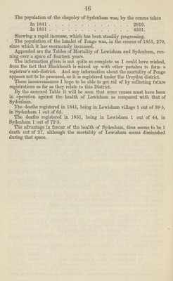
![44 lungs. In others, there is great exposure to the weather. In some, there is a great amount of loss of rest and exposure to the night air. In others, there is a great deal of confinement in close apartments and want of exercise. In some, exposure to noxious exhalations of various kinds. In some, an excessive amount of labour. In others, there is great exposure to heat or to cold; and last, though not least, in some there is great and over burthening mental anxiety. All these varieties must doubtless tell seriously upon the health more or less of districts generally. LEWISHAM. The parish of Lewisham [so called from læsew, a meadow, and ham, a village], is situate upon a very undulating tract of land; is bounded upon the north by the parish of Greenwich and of St. Paul's, Deptford; on the north-west and west by the parish of Camberwell; on the south by the parish of Beckenham, which here forms a tongue of land, separating it from the hamlet of Penge; on the south by the parish of Bromley; on the east by the parish of Lee; on the north-east by the parishes of Kidbrooke and Plumstead. The village of Penge, a hamlet of Battersea, is bounded on the north and north-east by the parish of Beckenham; on the north-west by the parish of Camberwell; on the west by a point of the parish of Lambeth; on the south and south-east by the parish of Croydon. The District is intersected by the river Ravensbourne, which takes its rise on Keston Common, not far from the borders of Surrey, and near an old fortified camp which Drs. Tabor and Hasted suppose to have been the encampment of the Roman legions under Aulus Plautius, whilst awaiting the arrival of the Emperor Claudius. Taking a most sinuous course, it flows north north-west at the base of Bromley Hill, between the parishes of Hayes and Bromley, receiving three branches in Lord Farnborough's park, and proceeding to Southend, expands into a broad sheet of water; again narrowing, it continues its course through the fields, and near Catford Bridge unites with the small river Chaffinch, or Poole River (which receives two branches from the Norwood hills), and flowing on the north-west side of Lewisham across Brockley Road, did re ceive the water of the Lady Well, which since the building of the new sewer in this road has been closed up. It also receives, after passing nearly through Lewisham, the stream of water called the Ravensbourne Brook, which runs through the entire length of the village by the road side; and which takes its origin from some springs situate upon Rushey Green; also the small stream called the Lee Bourne or Quaggy. Thence proceeding to Deptford, the river empties itself into Deptford Creek, which is continuous with it and the Thames. In its course it turns several mills, and supplies the Kent Waterworks Com pany for the use of the inhabitants of Greenwich, Deptford, and parts of Blackheath and Lewisham, Camberwell, Peckham, and the Government yards of Woolwich and Deptford. On either side of the Ravensbourne, the country rises until it attains on the east side, at the highest point of Blackhcath, an elevation of 155 feet above the mean sea level.](https://iiif.wellcomecollection.org/image/b18245122_0052.jp2/full/800%2C/0/default.jpg)