[Report 1912] / Medical Officer of Health, Wakefield City.
- Wakefield (England). City Council.
- Date:
- 1912
Licence: Attribution-NonCommercial 4.0 International (CC BY-NC 4.0)
Credit: [Report 1912] / Medical Officer of Health, Wakefield City. Source: Wellcome Collection.
11/132 (page 7)
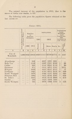
![.Newton Bar and for a. distance o>ver ai mile. At the broadest part, namely, between the top of Balne Lane and Eastmoor, it extends for a distance of three-quarters of a> mile. The sandstone comes very near the surface, and is readily exposed by ordinary building' excava¬ tions. The central part of the City stands on this rock. On the south side of the river, a considerable area of the district is over the Oaks Bock. On die north side this rock extends froim ai line drawn between the upper end of Oolck and Bottle Lane on the west and Bull Bridge Beck at ai point 300' yards, north of Bull Bridge on the east and runs south, including that prominent feature in the landscape, Sandal Castle, and the area, of Slandal Village and Milnthorpe. At the southern extremity of the district the Woolley Edge Bock appears, and on this stands the upper part of Neiwmillerdam (Hill Top). Gallows Hill stands on another part of the Oaks Rock, and there is also' air area, of sandstone extending between Belle Isle and the Barnsley Canal. Doncaster Road runs along the middle of this latter area of rock, and on it stands a considerable part, of Belle Vue. The City is wholly within the watershed of the river Calder. The principal branches of the river wit him the City are, on the north side, the Ings Beck, which divides into subsidiary branches the Alver- thorpe and Ba.lne Becks, and on the south] side the O'wler and Bull Bridge Becks. The Calder is canalised1 within the City. The town is a very old one, being mentioned in the Domesday Book. In former times chiefly residential, it is now1 also the centre of a, great number of industries, such as woollen and worsted factories, iron works of different kinds, glass bottle works, chemical works, malting and brewing, flour mills, and coal mining. There isi only one working coal shaft within the City, but. a number of coal pits are. in the neighbourhood. There is ai corn and cattle market, the latter1 a. very large one. The town contains many important institutions, and offices, such as the County Hall of the West Riding of Yorkshire, the West. Riding Lunatic Asylum, H.M1 Prison, the Clayton Hospital and Dispensary, and the Workhouse and Infirmarv of the Wakefield Union. e/ Particulars, of the eleven Ward si into Avhich. the City is divided was given in the Annual Report for 1911. POPULATION. The population of Wakefield is estimated by the Registrar- General at the middle of 1912 at 51,942, which represents an increase of 344 on the estimated population of the previous year. The increase is calculated on the ratio' of increase which was obtained •during the decade preceding the census of 1911.](https://iiif.wellcomecollection.org/image/b30227331_0011.jp2/full/800%2C/0/default.jpg)