Report of Dr. Sidney Coupland on the outbreak of small-box in the Dewsbury Union in 1891-2.
- Sidney Coupland
- Date:
- 1894
Licence: Public Domain Mark
Credit: Report of Dr. Sidney Coupland on the outbreak of small-box in the Dewsbury Union in 1891-2. Source: Wellcome Collection.
Provider: This material has been provided by The University of Leeds Library. The original may be consulted at The University of Leeds Library.
15/250 (page 5)
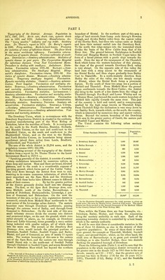
![PA] Topography of the District. Acreage. Population in 1871* 1881, 1891. Birth rate, death rate, zymotic death rate in 1891 and 1892. Industries, Manufactures, Sfc. The heavy woollen industry and rug trade. Sanitary state. Br. Thome's report in 1878. Dr. Barry's reports in 1886. Privy middens, Back-to-bacJc houses. Provision for isolation of cases of infectious disease. The fever block at the union worhhouse infirmary. Vaccination returns. Prevalence of zymotic disease. Previous outbreaks of small- pox. Dewsbury.—Sanitary administration. Statistics of zymotic disease in past years. The Corporation Hospital for infectious diseases. Crow Nest Convalescent Home. Procedure in dealing with small-pox. Ambulance. Disin- fection. Vaccination returns 1891-92. Batley.—Sani- tary administration. The Small-pox Hospital, llling- worth's disinfector. Vaccination returns, 1891-92. Sta- tistics of zymotic disease. Morley.—Sanitary adminis- tration. Temporary small-pox hospital. Vaccination. Zymotic mortality statistics. Ossett.—Sanitary adminis- tration. Feoer hospital. Vaccination and mortality sta- tistics. BiRSTAL.—Sanitary administration. Vaccination and mortality statistics. Heckmondwike. — Sanitary administration. Vaccination statistics. Liversedge.— Sanitary administration. Vaccination and mortality statis- tics. Mirfield.—Sanitary administration. Vaccination statistics. Ravensthorpe. — Sanitary administration. Mortality statistics. Soothill Nether. Sanitary ad- ministration. Vaccination statistics. Soothill Upper. —^Sanitary administration. Vaccination and mortality statistics. Thornhill.—Sanitary administration. Vac- cination and mortality statistics. The Dewsbury Union, which is co-terminous with the Dewsbury Registration District, is situated in the southern, populous manufacturing part of the West Riding of Yorkshire, below the meridian of Leeds. It is contiguous on the north to the North Brierley, Bramley, Holbeck, and Hunslet Unions, on the east and south-east to the Wakefield Union, on the south and south-west to the Huddersfield Union, and on the west to the Halifax and North Brierley Unions, its boundaries being almost equidistant (about three miles) from Leeds, Bradford, Huddersfield, and Wakefield.* The area of the whole district is 25,284 acres, and the population (census 1891) 162,596. The following account of the topography of the district is taken from a report by Dr. Thome Thome to the Local Government Board in 1878 f :— Speaking generally of the district, it consists of a series of steep undulations intersected by numerous valleys, at times deep and narrow. Here and there are broad, elevated plateaux, and to the south is a considerable expanse of low-lying ground, which forms part of the Calder Valley. This river flows through the district from west to east, receiving in its course numerous tributaries, of which the most important are the Spen Beck and the Dewsbury Beck. Both these becks have different names in different parts of their courses. ... By far the greater portion of the district generally divides itself into two drainage areas. The first, or the Spen Beck Drainage Area, con- tains Mirfield, north of the Calder, Ravensthorpe, a portion of Dewsbury, Heckmondwike, Liversedge, a por- tion of Gomersal, and Birkenshaw. On the west the boundary of this area, so far as this registration district is concerned, extends from Mirfield Moor northwards to the west corner of the Li\ ersedge urban district. The eastern boundary runs tlirough IJewsbury northwards, passing through the extreme west of Batley, and through Great Gomersal to Birkenshaw. On the west side of this area small tributary streams divide the country into distinct and prominent ridges, on the east the ground, which rises rather abruptly in places, as, for example, at Dewsbury Moor and Little Gomersal, forms generally a wavy outline being indented with smaller valleys, all of which drain into the main one. The second, or the Dewsbury Beck Drainage Area, would include the principal portions of Dewsbury, Soothill Nether, Soothill Upper, and Batley, Birstal, and part of Gomersal, an area of nearly 11 square miles. The western boundary of this area is the eastern one of the Spen Beck, and the eastern one runs through Ossett Street side to the north-east of Soothill Nether through Chidswell in Soothill Upper, and across Bruntclilfe Moor to Adwalton Moor which lies beyond the northern • The borough of Dewsbury is about 8 miles from Leeds, R miles from Bradford, 5i miles from Huddersfield, 5 miles from Wakefield. t Report to the Local Government Board on the sanitary condition of the Dewsbury Registration District with special reference to the prevalence of infectious diseases in the district. H I. boundary of Birstal. In the northern part of this area a ridge of land extends from Lamp ands through Howden Clough, and divides Batley valley from the narrow valley of the Howley Beck, but these two valleys unite at Batley and have their natural outfall into the Dewsbury Beck. To the north this ridge merges into the watershed which divides the basin of the River Calder from that of the River Aire. The ground between Earlsheaton in SoothiU Nether and Hanging Heaton in Soothill Upper takes the form of a broad plateau with a gentle slope towards the south. From the top of the escarpment of the Thornhill Rock which forms the western boundary of this plateau, the slope of the ground towards Dewsbury Beck valley is very abrupt. On the opposite side of this vaUey the land rises with a steep ascent to the escarpment of the Birstal Rocks and then slopes gradually from Batley Carr to StainclifFe. In a north-westerly direction from Batley the sides of the valley rise less steeply except at Birstal, where the Birstal Rock forms a prominent feature. To the south of these two areas lies a portion of Mirfield and Thornhill. From Mirfield Moor the ground slopes southwards towards the River Calder; the district also lying to the north of a line drawn from the village of Thornhill through Fox-Royd and Lower Whitley and on to Heaton Moor, just beyond the south-western boundary of Mirfield falls rapidly towards the same river. This part of the country is bold and varied, and is conspicuou^y marked by the high range known as Thornhill Edge. From Thornhill Edge the inclination is very steep down to the Smithy Beck, towards which, on the south, the country, which is intersected by numerous deep and narrow valleys, drains. Beyond the eastern boundary of the Dewsbury Beck area lie the greater portioa of Ossett, the eastern part of Soothill Upper and Morley. The Union contains the following urban sanitary districts :— Urban Sanitary Districts. Acreage. Population, 1891. 1. Dewsbury Borough 1,468 29,847 2. Batley Borough . . - - 2,039 28,719 3. Birkenshaw .... 925 2,553 i. Birstal 1,233 6,528 5. Gomersal ..... 1,096 3,923 6. Heckmondwike - . . . 697 9,709 7. Liversedge .... 2,130 13,668 8. Mirfield 3,413 11,707 9. Morley Borough .... 3,381 18,725 10. Ossett Borough .... 8,105 10,984 11. Ravensthorpe .... 353 5,134 12. Soothill Nether .... 662 5,848 13. Soothill Upper .... 1,897 6,646 14. Thornhill 3,602 9,606 Total 25,900* 162,596 ' In the Registrar-Greneral's summary the total acreage is given as 25,284 acres, the area for Morley being stated at 2,765 acres. The above figures are those quoted in the Annual Summary of the Medical Officer to the County Council of the West Riding, 1892. Thus, within the Union there are four boroughs, viz. : Dewsbury, Batley, Morley, and Ossett, the corporation being the sanitary authority in each case. Each of the remaming township districts is controlled by a local board, which is the sanitary authority. It will be seen that there is considerable variation in the area of these 14 districts, as also in the density of their respective populations. In many of them there is much open ground, for example at Thornhill, Mirfield, Soothill Upper, and around Ossett; whilst, on the other hand, the small area of Ravensthorpe is in great part covered by fiwellings, as is also Soothill Nether, these two districts flanking the populated borough of Dewsbury. From the following table (Table I.) it will be seen that the population in the whole registration district increased at a far greater rate in the decade 1871 to 1881 than in the next decade, namely, as 1 23 : 1*057; that the greatest rate of increase has been in Morley (191 for the 20 years 1871- 1891), Thornhill (1-52), Batley (1-37), and the Soothills 1-36).](https://iiif.wellcomecollection.org/image/b21518592_0015.jp2/full/800%2C/0/default.jpg)