The water supply of Bedfordshire and Northamptonshire, from underground sources: with records of sinkings and borings / by Horace B. Woodward ... and Beeby Thompson ... with contributions on rainfall by Hugh Robert Mill.
- Horace Bolingbroke Woodward
- Date:
- 1909
Licence: In copyright
Credit: The water supply of Bedfordshire and Northamptonshire, from underground sources: with records of sinkings and borings / by Horace B. Woodward ... and Beeby Thompson ... with contributions on rainfall by Hugh Robert Mill. Source: Wellcome Collection.
116/246 (page 108)
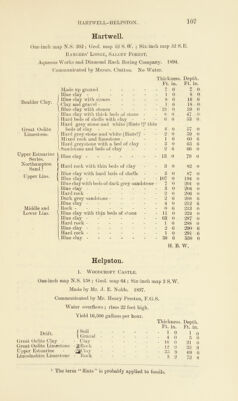
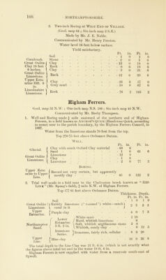
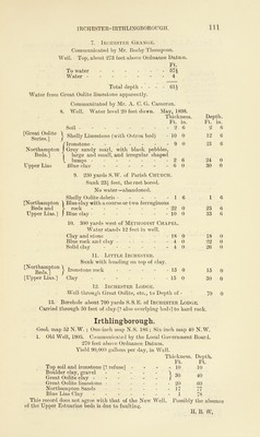
![2. Two-inch Boring at West End of Village. (Geol. map 64 ; Six-inch map 2 S.E.) Made by Mr. J. E. Noble. Communicated by Mr. Henry Preston. Water level 16 feet below surface. Yield satisfactory. Ft. in. Ft. Soil ------- - 1 0 1 Cornbrash. Stone - 2 0 3 Great Oolite Clay ------- - 15 0 18 Clay 18 feet - Rock ------- - 0 6 18 6 inches. _ Clay - 3 0 21 Great Oolite Limestone. j- Rock - 12 0 33 Upper Estu- arine 33ft. 6 - in. \ Clay 1 Grey marl - 23 - 10 6 0 57 67 Lincolnshire ] Limestone. J V - Rock - 76 2 143 in. 0 0 0 G 6 6 0 0 o Higham Ferrers. Geol. map 52 N.W. ; One-inch map N.S. 186 ; Six-inch map 40 N.W. Communicated by Mr. Beeby Thompson. 1. Well and Boring made f mile eastward of the northern end of Higham Ferrers, in a held known as Anchor’s Quick (Handcross Quick, according to some) near to the parish boundary, by the Higham Ferrers Council, in 1897. Water from the limestone stands 70 feet from the top. Top 270 75 feet above Ordnance Datum. Glacial. Great Oolite Limestone. 1 ^ 1 L Well. Clay with much Oxford Clay material Sand ------- Limestone Clay imestone Ft. in. Ft. in. - 60 6 - 1 0 61 6 - 12 0 - 1 8 - 2 0 77 2 45 0 122 2 >ok known as “ Red Boring. LIppei Estu- (Recorj 110£ very certain, but apparently aune tojjpper-j mostly clay ? . . 11>. .* Link” (Mr. Spong’s held), f mile N.W. of Higham Ferrers. Top 177 '81 feet above Ordnance Datum. Thickness. Depth. Ft. in. Ft. in. Soil - - - - - * Great Oolite ? / Bubbly limestone (“ rammel ”) white—much \ Limestone, t coral in it - - - - - / EsuSrine. {Purllle cla>' z T , /White sand ower ^ j jjar(j9 whitish limestone - Northampton J *SUQ1|1,le ^ Soft, whitish argillaceous stone Sand. \ 5 ' V Whitish, sandy clay 1 0 2 8 1 0 3 3 4 0 7 3 1 10 6 2 4 6 12 5 Ironstone ljronst0ne, fairly rich, cellular Series. J ’ U pper / Blue clay Lias. t 8 3 20 16 0 36 8 The total depth to the Lias Clay was 21 ft. 6 in. (which is not exactly what the figures above total to) and to the water 18 ft. 6 in. Higham Ferrers is now supplied with water from a reservoir south-east of Sywell.](https://iiif.wellcomecollection.org/image/b28127407_0116.jp2/full/800%2C/0/default.jpg)