The water supply of Bedfordshire and Northamptonshire, from underground sources: with records of sinkings and borings / by Horace B. Woodward ... and Beeby Thompson ... with contributions on rainfall by Hugh Robert Mill.
- Horace Bolingbroke Woodward
- Date:
- 1909
Licence: In copyright
Credit: The water supply of Bedfordshire and Northamptonshire, from underground sources: with records of sinkings and borings / by Horace B. Woodward ... and Beeby Thompson ... with contributions on rainfall by Hugh Robert Mill. Source: Wellcome Collection.
124/246 (page 116)
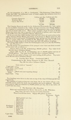
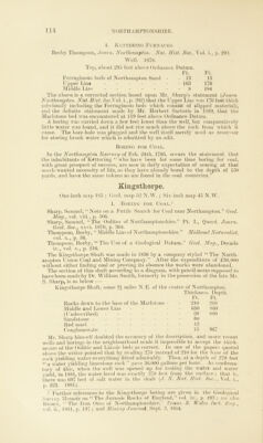
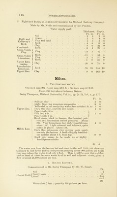
![Litchborough. Geol. map 53 S.Pb ; One-inch map N.S. 202 ; Six-inch map 50 S. E. Communicated by Mr. J. B. Williams to Mr. B. Thompson. Boring, near to a Spring, about } mile W. of the Village. (1899 about.) [Drift] ? Soil - Ft. - 2 Ft. 2 Yellow clay - - - - 8 10 Blue clay - - - - 15 Yellow clay - - - - 2 27 Sand and stone - - - - - 17 Hard brown rock - - - - 2 Sand and Stone - - - - 6 52 Blue Clay - - - - - 9 61 the boring. No use was made of Long Biickby. Geol. map 53 N.E. ; One-inch map N.S. 185 ; Six-inch map 36 N.E. From. Dr. R. Bruce Low’s Report to the Local Government Board on the Water Supply of Long Buckby. 1896. There were, in 1896, at Long Buckby, 116 wells, some six of which were public wells. The depth of the wells varied according to their position on the slope. Including the surface springs nine were under 10 feet in depth ; twenty-eight from 10 to 20 feet ; forty-one from 20 to 40 feet ; ten were over 40 feet deep. Of the remaining twenty-eight no accurate depths could be ascertained. Two wells were stated to be 85 feet deep. At the Eastern end of the village superficial gravel beds supply the water, towards the middle of the village similar gravel beds resting on Upper Lias Clay and covered by variable amounts of Boulder Clay. At the western end wells derive their water from the Middle Lias. 1. Boring at Long Buckby. (Six-inch map 37 N.W.) Communicated by Mr. Beeby Thompson from information supplied by Mr. Taylor, Clerk of the Works. As a preliminary to a public water supply a boring was made on the high ground to the E. of Long Buckby just in the angle between the two roads leading to Northampton and West Haddon respectively, and below is the section recorded :— Ft. in. Ft. in, 1. Loamy sand and flints 9 0 9 0 2. Sandstone . 21 0 30 0 3. Sandy clay - 19 0 49 0 4. Blue clay 185 0 234 0 5. Rock - . . . 9 0 243 0 6. Blue clay 5 6 248 6 7. Rock with water - 18 6 267 0 8. Blue clay 2 0 269 0 9. Grey rock 12 6 281 6 10. Blue clay 6 6 288 0 Below this alternating clay and rock to 332 6 Water stood 236 feet from the surface (see below). 2. Well at Long Buckby. Same situation as the boring. Communicated by Mr. Beeby Thompson from information derived from several sources, particularly Mr. Henry Martin’s foreman, and personal observations of the material. Drift and f Northampton^ 1. Sand. 2. 3. ,4. 5. 6. 7. Northampton f Sand. [ Upper Lias. Soil with flints and sand Saudstone Sand ------ Blue clay Clay with stones Hard bed with abundant ammonites Fish-bed, exceedingly hard, crys-1 talline and pyritous - - - / Ft. in. Ft. in, 9 0 9 0 21 0 30 0 20 0 50 0 162 0 212 0 21 0 233 0 1 0 234 0 0 3 234 o o](https://iiif.wellcomecollection.org/image/b28127407_0124.jp2/full/800%2C/0/default.jpg)