The water supply of Bedfordshire and Northamptonshire, from underground sources: with records of sinkings and borings / by Horace B. Woodward ... and Beeby Thompson ... with contributions on rainfall by Hugh Robert Mill.
- Horace Bolingbroke Woodward
- Date:
- 1909
Licence: In copyright
Credit: The water supply of Bedfordshire and Northamptonshire, from underground sources: with records of sinkings and borings / by Horace B. Woodward ... and Beeby Thompson ... with contributions on rainfall by Hugh Robert Mill. Source: Wellcome Collection.
48/246 (page 40)
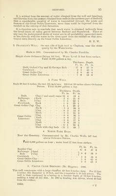
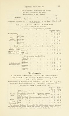
![Billington. 1. The Rectory. 2. S. of the Village. Geol. map 46 S.E. ; One-inch map N.S. 220 ; Six-inch map 31 N.E. 1. Information given by the Rector. Sunk 70 feet through clay, the upper part full of chalk-stones, the lower a clean light blue clay. Water comes in at 50 feet down (possibly from the Gault coprolite bed). 2. On the lower ground south of Billington, dug 70 feet and bored 90 feet, through clay, finding a good supply of water in sand (Lower Greensand). A, J. J. B. Bletsoe. Brickyard at Bourne End. Geol. map 52 S.W. ; One-inch map N.S. 186; Six-inch map 7 N.E. 200 feet above Ordnance Datum. Juassic Rocks of Britain, Vol. iv, p. 451. £11 f Greenish and yellowish sand, concretionary in' 1 twi«! 1 Places [ Grey and yellow clay r Fissile sandy and calcareous layers with Ostrea Jiabelloides ------- _ Tough grey and brown limestone (water) - Beds, Cornbrash Ft. 5 1 1 About in. 0 6 3 H. B. W. Blunham. Geol. map 52 S.E. ; One-inch map N.S. 204 ; Six-inch map 12 S.E. No public water supply. Shallow wells. Well at the Lodge, west of village. About 112 feet above Ordnance Datum. Chalky gravel 15 feet. [Boulder clay] Blue clay and stones. Bolnhurst. Geol. map 52 S.E. ; One-inch map N.S. 186; Six-inch map 8 S.W. Ponds on Boulder-clay have locally been use! as sources of water-supply. Bromham. 1. Bromham House. (W. H. Allen, Esq.) Communicated by Mr. Cameron, Geol. map One-inch N.S. 203 ; Six-inch map 11 S.W. Sunk 53 ft. 2 ins. ; the rest bored. 1897. No water found. Kellaways Beds. Cornbrash. Great Oolite Clay. Great Oolite Limestone. Estuarine Series. Thickness. Ft. in. Depth. Ft. in. Turf . . . - . 0 10 0 10 Surface Soil - - - - - 2 0 2 10 Mild clay - . 6 0 8 10 Dark clay ... - - 4 0 12 10 Blue rock - - 7 0 19 10 Rock - - 1 6 21 4 Clay . 7 0 28 4 Clay [with brachiopods] • - 0 10 29 2 •Blue rock .... - 24 0 53 2 Blue clay - 10 0 63 2 Rock •• - - - * - 3 0 66 2 Blue sand and clay - 0 6 66 8 Rock - 2 0 68 8 •Blue sand - Blue rock passed through and the boring was 2 ) 0 70 8 carried to a further depth of about 30 feet, making a total of 100 feet below the surface. ^ 29 4 100 0](https://iiif.wellcomecollection.org/image/b28127407_0048.jp2/full/800%2C/0/default.jpg)