The water supply of Bedfordshire and Northamptonshire, from underground sources: with records of sinkings and borings / by Horace B. Woodward ... and Beeby Thompson ... with contributions on rainfall by Hugh Robert Mill.
- Horace Bolingbroke Woodward
- Date:
- 1909
Licence: In copyright
Credit: The water supply of Bedfordshire and Northamptonshire, from underground sources: with records of sinkings and borings / by Horace B. Woodward ... and Beeby Thompson ... with contributions on rainfall by Hugh Robert Mill. Source: Wellcome Collection.
72/246 (page 64)
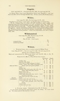
![Tingrith. Geol. map 46 N.W. ; One-inch map N.S. 220 ; Six-inch map 25 S.W. At Herne Dairy Farm [now Hernegreen Farm] near Tingrith, a well had been sunk 40 to 50 feet through Boulder-clay. (From a note by Mr.H.Bauerman.) Wilden. Geol. map N.S. 203 ; Six-inch maps 8 S.W., S.E. Supplied in part from “ water holes ” on Boulder Clay or Oxford Clay. “ At the vicarage there is a deep well still yielding a good supply, and adjoining upon the school property is a well seventeen feet deep, which was sunk about eighteen years ago, also yielding a plentiful supply of good water, and which has never been dry. At the ‘ Manor Farm ’ there is a good supply throughout. On the road leading toBenhold are several small holdings, includ- ing ‘ Fensome’s Farm,’ and some old cottages, owned by Mr. Ivett, brickmaker, supplied by wells on the premises.”—From the Bedfordshire Standard, August 11th, 1888. Willshamstead. Geol. map N.S. 203 ; Six-inch map 17 S.W. Cotton End. Dug 50 feet. Good supply. Ft. [Oxford] Clay 95 [Kellaways] Sand 5 Woburn. 100 1. Woburn Park, close to western corner!of Milton Wood. Geol. Map 46 N.W. ; One-inch map N.S. 220 ; Six-inch map 24 S.E. 446 feet above Ordnance Datum. Made and communicated by Messrs Le Grand and Sutcliff, 1898, to Mr. W. Whitaker. Water-level in March, 1898, 159 feet from surface. Alluvial Drift. [Lower Greensand.] / / \ / / \ Thickness. Depth. Ft. in. Ft. in. Yellow clay - - * - 1 0 1 0 Boulder clay (blue) 73 0 74 0 Fine sand (a little soakage of water) - Loam, stones and shells [brownish- grey clayey sand and quartz pebble] - 0 6 74 6 7 6 82 0 Sand - 5 0 87 0 Sandy clay Boulder clay [dark grey clay with bits of 3 0 90 0 chalk, flints and other stones] 16 0 106 0 Hard sandy clay - - - - 6 0 112 0 Sandy rock and clay ... Sand (dark grey) and clay mixed : water 37 0 149 0 touched at 161 feet 25 0 174 0 Fine sand and thin layers of clay 14 0 188 0 Sand ------- 3 6 191 6 Green sand, day and stones Green sand and clay (at 202 feet some- what dark greenish sand with hard 8 6 200 0 lumps, 21 0 221 0 Green sand - in 6 231 6 Green sand and clay - 20 6 252 0 5* 55* 55 55 17 0 269 0 2. Woburn Abbey. Information from Mr. T. Preston. An old well 80 feet deep has been found within the Abbey. It is now filled up. For many years it was used as a cess-pit,](https://iiif.wellcomecollection.org/image/b28127407_0072.jp2/full/800%2C/0/default.jpg)