The water supply of Bedfordshire and Northamptonshire, from underground sources: with records of sinkings and borings / by Horace B. Woodward ... and Beeby Thompson ... with contributions on rainfall by Hugh Robert Mill.
- Horace Bolingbroke Woodward
- Date:
- 1909
Licence: In copyright
Credit: The water supply of Bedfordshire and Northamptonshire, from underground sources: with records of sinkings and borings / by Horace B. Woodward ... and Beeby Thompson ... with contributions on rainfall by Hugh Robert Mill. Source: Wellcome Collection.
73/246 (page 65)
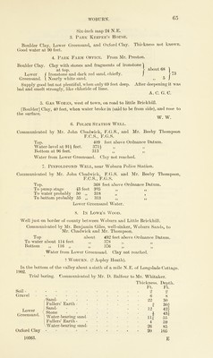
![WOBURN. Six-inch map 24 N.E. 3. Park Keeper’s House. Boulder Clay, Lower Greensand, and Oxford Clay. Thickness not known. Good water at 90 feet. 4. Park Farm Office. From Mr. Preston. about 68 r* n 73 Boulder Clay. Clay with stones and fragments of ironstone ^ at top. Lower f Ironstone and dark red sand, chiefly. Greensand. \ Nearly white sand. Supply good but not plentiful, when only 69 feet deep. After deepening it was bad and smelt strongly, like chloride of lime. A.C. G. C. 5 5. Gas Works, west of town, on road to little Brick hill. [Boulder] Clay, 40 feet, when water broke in (said to be from side), and rose to the surface. W. W. 6. Police Station Well. Communicated by Mr. John Chadwick, F.G.S., and Mr. Beeby Thompson F.C.S., F.G.S. Top. 409 feet above Ordnance Datum. Water-level at 91^ feet. 3711 „ ,, Bottom at 96 feet. 313 ,, ,, Water from Lower Greensand. Clay not reached. 7. Pinfoldpond Well, near Woburn Police Station. Communicated by Mr. John Chadwick, F.G.S. and Mr. Beeby Thompson, F.C.S., F.G.S. Top. 368 feet above Ordnance Datum. To pump stage 43 feet 325 ,, ,, To water probably 50 ,, 318 „ , To bottom probably 55 ,, 313 ,, ,, Lower Greensand Water. 8. In Lowe’s Wood. Well just on border of county between Woburn and Little Brickhill. Communicated by Mr. Benjamin Giles, well-sinker, Woburn Sands, to Mr. Chadwick and Mr. Thompson. Top about 492 feet above Ordnance Datum. To water about 114 feet ,, 378 ,, ,, Bottom „ 116 „ „ 376 „ „ Water from Lower Greensand. Clay not reached. ’Woburn. (? Aspley Heath). In the bottom of the valley about a sixth of a mile N.E. of Longslade Cottage. 1902. Trial boring. Communicated by Mr. D. Balfour to Mr. Whitaker. Soil - Gravel Lower Greensand. Thickness. Ft. 2 Depth. Ft. 2 - - - 6 8 /Sand- . • 22 30 Fullers’ Earth - - - - 1 30| Sand- - - 12 42f Stone - 4 431 Water-bearing sand - - - mt 11# 55 Fullers’ Earth - - - - 4 59 Water-bearing sand- - - - 26 85 • * ■* r r *• • 20 105 Oxford Clay](https://iiif.wellcomecollection.org/image/b28127407_0073.jp2/full/800%2C/0/default.jpg)