Catalogue of the library removed from Stowe House, Buckinghamshire. Which will be sold by auction, by Messrs. S. Leigh Sotheby & Co. ... on ... 8th January, 1849, & eleven following days ... and ... 29th January, 1849, & eleven following days.
- Harriet Beecher Stowe House
- Date:
- [1849]
Licence: Public Domain Mark
Credit: Catalogue of the library removed from Stowe House, Buckinghamshire. Which will be sold by auction, by Messrs. S. Leigh Sotheby & Co. ... on ... 8th January, 1849, & eleven following days ... and ... 29th January, 1849, & eleven following days. Source: Wellcome Collection.
331/364 page 321
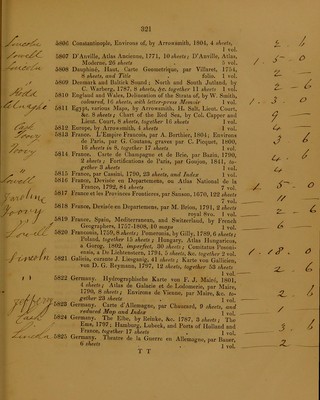
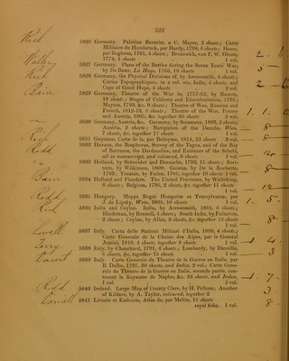
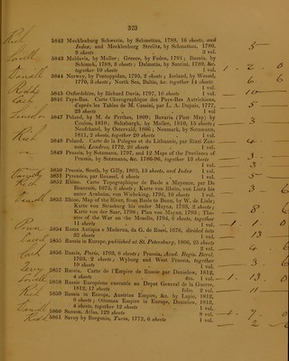
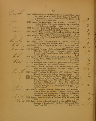
![5806 5807 5808 5809 5810 5811 5812 5813 5814 5815 5816 5821 t ) 5822 Constantinople, Environs of, by Arrowsmith, 1804, 4 sheets> 1 vol. D’Anville, Atlas Ancienne, 1771, 10 sheets; D’Anville, Atlas, Moderne, 26 sheets . 5 vol. Dauphin6, Haut, Carte Geometrique, par Villaret, 1754, 8 sheets, and Title . folio. 1 vol. Denmark and Baltick Sound ; North and South Jutland, by C. Warberg, 1787, 8 sheets, §c. together 11 sheets 1 vol. England and Wales, Delineation of the Strata of, by W. Smith, coloured, 16 sheets, with letter-press Memoir 1 vol. Egypt, various Maps, by Arrowsmith, H. Salt, Lieut. Court, &c. 8 sheets; Chart of the Eed Sea, by Col. Capper and Lieut. Court, 8 sheets, together 16 sheets 1 vol. Europe, by Arrowsmith, 4 sheets . 1 vol. France. L’Empire Francois, par A. Berthier, 1804; Environs de Paris, par G. Coutans, graves par C. Picquet, 1800, 16 sheets in 8, together 17 sheets 1 vol. France. Carte de Champagne et de Brie, par Bazin, 1790, 2 sheets ; Fortifications de Paris, par Goujon, 1841, to- gether 3 sheets . 1 vol. France, par Cassini, 1790, 23 sheets, and Index 1 vol. France, Devisee en Departemens, ou Atlas National de la France, 1792, 84 sheets . 7 vol. France et les Provinces Frontieres, par Sanson, 1670, 122 sheets 7 vol. France, Devisee en Departemens, par M. Brion, 1791, 2 sheets royal 8vo. 1 vol. France, Spain, Mediterranean, and Switzerland, by French Geographers, 1757-1808, 10 maps 1 vol. Franconia, 1759, 8 sheets; Pomeronia, by Gilly, 1789, 6 sheets; Poland, together 15 sheets; Hungary, Atlas Hungaricus, a Gorog, 1802, imperfect, 30 sheets; Comitatus Posoni- ensis, a De Lichtenstern, 1794, 5 sheets, &c. together 2 vol. Galicia, curante J. Liesganig, 41 sheets; Karte von Gallicien, von D. G. Reymann, 1797, 12 sheets, together 53 sheets 1 vol.' Germany. Hydrographische Karte von F. J. Maire, 1801, 4 sheets; Atlas de Galacie et de Lodomerie, par Maire, 1790, 8 sheets; Environs de Vienne, par Maire, &c. to- gether 23 sheets . q vo]t Germany. Carte d’Allemagne, par Chaucard, 9 sheets, and reduced Map and Index . l Vol. Germany. The Elbe, by Reinke, &c. 1787, 3 sheets; The Ems, 1797; Hamburg, Lubeck, and Ports of Holland and France, together 17 sheets . l vol, Germany. Theatre de la Guerre en Allemagne, par Bauer, 6 sheets . . ] Vol, T T k - / • , /“ - z. • -— t- _ ^ /. J . o 9 — — 3 - / ' / j- _ <9 // _ 4 /. s . , 3 . / / — J . /](https://iiif.wellcomecollection.org/image/b22013660_0331.jp2/full/800%2C/0/default.jpg)