A geographical and statistical display of the locality, relation, superficies, and population of each county, section, district, and colony of the British Empire ... Russia, Prussia, France, the Netherlands, Germany, and the peninsula of Spain and Portugal, and the United States of North America, and China.
- John Marshall
- Date:
- [1833?]
Licence: Public Domain Mark
Credit: A geographical and statistical display of the locality, relation, superficies, and population of each county, section, district, and colony of the British Empire ... Russia, Prussia, France, the Netherlands, Germany, and the peninsula of Spain and Portugal, and the United States of North America, and China. Source: Wellcome Collection.
Provider: This material has been provided by The Royal College of Surgeons of England. The original may be consulted at The Royal College of Surgeons of England.
14/126
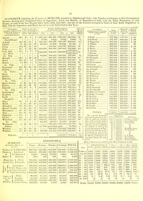
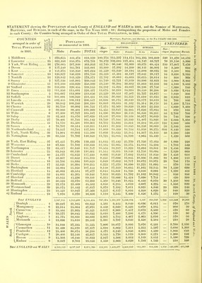
![STATEMENT shewing the Geographical Position of each of the 32 Counties of IRELAND, with the distance in Statute miles and bearing of the Assize Town of each County from Dublin ; shewing also the Superficies of each County in Square Miles and in Irish Plantation acres, with the Number of Houses and Inhabitants to each Square Mile, and the proportion of Acres to each Inhabitant in 1821. The 4 Archiepiscopal Sees, are printed in Old Roman ©a©S&aiL£, and the 18 Bishopricks in ©ft Roman, the Assize Towns are printed, in Small Capitals, except where they are Bishopricks, those noted with % are Sea Ports, and Ports of Entry, with Custom Houses ; and those noted f or 1 return respectively 1 and 2 Members to Parliament, the Counties noted $ are interior, and the others Maritime. . Ape Clear the S W. extremity of Ireland in the County of Cork, is in North Latitude 51° 19» and 9° 24' of West Longitude ; and Fair Head, the ertZme N E point in the County of Antrim, is in Latitude 55° 44' North, and 6° 2' of West Longitude, a mean line of J07 Geographical or 356 Statute miles. Cansore Point, in the County of Wexford, is the extreme S. E. point, and is in Latitude 52° 11' North, and 6° 20' of West Longitude. The County of Kerry, extends further West than Cape Clear ; the Bi.askets, off the North point of entrance to Dingle Bay, being m 10° 22' of West Longitude,-this is the most Westerly Point of all Ireland : the average mean length of which from North to South, is 2° 46' Degrees of Latitude and the mean average breadth about o Decrees of Longitude which accords with the Square miles as below The Degree of Longitude in the Latitude of Ireland, being about 36£ Geographical miles. Athlone see No. 4, is seated on both hanks of the Shannon, just below Lough Ree, and is mostly in Roscommon. Counties. Principal Towns. to SI l-i f* ^ DfUmi/l, City of, and 1 University.. 1 do. County Balbriyan Town of 2 Louth Ardee 3 Meath /Bratl), Navan 4 § Westmeath Kilbegan ( Partly in Roscommon, No. 28. ) Town of 5 § Longford Granard 6 § Kildare.. Athy, Naas, and Maynooth 7 § King’s t Por tar ling ton 8 § Queen’s ©sssory 9 § Carlow Heigfiltn, with Ferns 10 & Kilkenny Gowran, Durrow City of 11 Wicklow Arklow 12 Wexford, .ifmis, with Leighlin tRoss Total Province of LEINSTER. f' City of I 13 Waterford Tallow, Lismore 14 § Tipperary . . t©a§r?and Emly | 15 Cork, East ©lope, f Mallow do., West .. * Baltimore, f Kinsale City of Kerry Ardfcrt Sf Aghadoe, Killarney Limerick Rathkeale City of Clare l&illaloe, + Ennis Total Province of MUNSTER. ] 16 I17 1.18 t I3ohmpatrtck « t Belfast f Carrickfergus Cavan t Monaghan t Enniskillen Omagh Donegal * t HonhonheiTB f 19 Down Eromorc, % t Newry 20 Antrim + Lisburn, Antrim Town of R5 21 § Cavan IXilnrore g . 22 § Armagh Lurgan ^ ] 23 § Monaghan Carrickmacross H 24 Fermanagh Maguires Bridge ^ 25 § Tyrone ©logger, + Duncannon I 26 Donegal Rapfioc, Ballyshannon (J>7 Londonderry 5 t Coleraine Total Province of ULSTER. [28 § Roscommon ©Ipf)in, Boyle | 29 Leitrim Drumsna to 1 30 Sligo Ardnaree, Ballymote 5 ^ 31 Mayo, IXtllala, and Achonry ZWestport 5 I 32 Galway,©?4aiH,©Ioirfert Sf Kilmacdgh. § 1^33 Town of to Total Province of CONNAUGHT. Total IRELAND. Lough Neagh, surrounded by Nos. 19, 20, 22, 25, and 27. Assize Town. 53° 23' North Lat. Swords S f Drogheda * f Dundalk Trim Mullingar f Athlone Longford litiftare Phillipstown Maryborough f Carlow Knocktopher f Kilkenny Wicklow J f Wexford * t 023aterfortr f Dungarvon f Clonmell f Youghall f Bandon 3 t Cork f Tralee Kilmallock « I fltmertfk Clare Roscommon Carrick * f Sligo Castlebar Ballinasloe % 1 Galway Superficies Proportion t<f Acres to each Inhabitnt in 1821. of ASSIZE TOWN, from DUBLIN. Square Miles. Irish Planta- tion Acres. in 1 Houses 821. Inhabit. 6° 20' W. Long. ] 7 due N. j | 224 142,050 161 520 .42 23 // 1 40 • J > 173 110,750 123 688 1 .07 22 W. by N. 1 512 327,900 54 311 2 . 38 | 55 j J 301 231,550 63 357 1 .83 59 209 134,150 90 514 1 .20 25 W. by S. 369 236,750 44 268 2 .40 38 due W. 440 282,200 51 298 2 .16 40 W. S. W. 367 235,300 63 366 1 .71 39 S. W. 214 137,050 61 369 1 .75 63 « ] 57 j > 469 300,350 63 388 1 .66 24 due S. 1 486 311,600 35 228 2 .81 63 535 342,900 54 319 2 . 4,356 2,792,550 64 403 1 .95 75 S. by W. \ 95 S. S. W. J | 410 262,800 58 381 1 .66 75 S. W. | 867 554,950 08 400 1 .55 115 -j 137 ’ 1,038 1,048,800 70 446 1 .42 124 n j 144 W. S. W. | 1 1,012 647,650 35 213 3 . 107 W. by S. 1 i 604 744 386,750 70 459 1 .33 94 « j 112 476,200 47 280 2 .30 5,275 3,377,150 58 367 1 .70 74 N. N. E. 544 348,650 109 598 1 .06 84 N. by E. ] 86 // \ ^ 605 387,200 78 447 1 .38 54 N. by W. 470 301,000 73 415 1 .50 62 due N. 283 181,450 128 697 .90 62 N. by W. 280 179,600 115 624 1 . 79 N. N. W. 448 283,450 50 292 2 .16 87 724 463,700 63 362 1 .77 111 1,061 679,550 32 234 2 .75 164 N. by W. 479 318,500 72 405 1 .60 4,894 3,143,000 73 408 1 .60 69 W. by N. 541 346,050 69 385 1 .60 77 W. N. W. 400 255,950 54 312 2 103 » 386 247,150 ! 70 378 1 .66 114 W. by N. 1,235 790,600 43 237 2 .66 72 W. by S. i 103 J 1,546 989,950 37 218 3 . i 4,108 1 2,630,300 48 270 | 2 .36 1 ( 11,943,000 '’■m\ 51., MO 61 365 j 1 .75 1](https://iiif.wellcomecollection.org/image/b22297030_0016.jp2/full/800%2C/0/default.jpg)