Volume 1
A dictionary of Greek and Roman geography / by various writers ; edited by William Smith.
- Date:
- 1873
Licence: Public Domain Mark
Credit: A dictionary of Greek and Roman geography / by various writers ; edited by William Smith. Source: Wellcome Collection.
45/1140 (page 23)
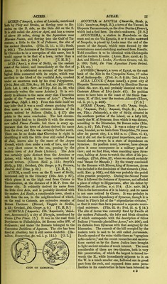
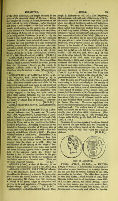
![ACROTHOUM. 30, vii. 4. § 14; Leake, Morea, vol. ii. p. 203; Boblaye, RecJierches, p. 123.) ACROTHO'UM, or ACROTHOl QkKp6eo>ov Her. vii. 22; ^AKpddcoot, Thuc. iv. 109; Strab. p. 331; Scyl. p. 26 ; Steph. B. s. v.; Acroathon, Mel. ii. 2; Acrothon, Plin. iv. 10. s. 17: Eth. ’AKp66wos^ ’AKpodmrrjs'), a town in the peninsula of Acte, in Chalcidice in Macedonia, situated near the extremity of the peninsula, probably upon the site of the mo- dern Lavra. Strabo, Phny, and Mela seem to have supposed that Acrothoum stood upon the site of Mt. Athos; but this is an impossibility. [Athos.] It was stated by Mela and other ancient writers that the inhabitants of Acrothoi lived longer than ordi- nary men. Mannert and others erroneously suppose Acrothoi to have been the same place as the later Uranopolis. (Leake, Northern Greece, vol. iii. p. 149.) ACTE' (’A/ct^), signified a piece of land running into the sea, and attached to another larger piece of land, but not necessarily by a narrow neck. Thus Herodotus gives the name of Acte to Asia Minor as compared with the rest of Asia (iv. 38), and also to Africa itself as jutting out from Asia (iv. 41). Attica also was originally called Acte. (Steph. B. s. V.') LAttica.] The name of Acte, however, was more specifically applied to the easternmost of the three promontories jutting out from Chalcidice in Macedonia, on which Mt. Athos stands. It is spoken of under Athos. A'CTIUM Q'Aktiov: Eth. ''Aktios, Actius: Adj. 'AktiukSs, Actiacus, also ''Aktios, Actius), a pro- montory in Acamania at the entrance of the Am- braciot Gulf (^Gulf of Arta) ofi which Augustus gained his celebrated victory over Antony and Cleopatra, on September 2nd, b. c. 31. There was a temple of Apollo on this promontory, which Thucydides mentions (i. 29) as situated in the territory of Anactorium. This temple was of great antiquity, and Apollo derived from, it the surname of Actius and Actiacus. There was also an ancient festival named Actia, celebrated here in honour of the god. Augustus after his victory enlarged the temple, and revived the ancient festfral, which was henceforth celebrated once in four years (Trej/rae- TT)p'is, ludi quinquennales'), with musical and gym- nastic contests, and horse races. (Dion Cass. li. 1; Suet. Aug. 18.) We learn from a Greek inscription found on the site of Actium, and which is probably prior to the time of Augustus, that the chief priest of the temple was called TepaTro'Aos, and that his name was employed in official documents, like that of the first Ai'chon at Athens, to mark the date. (Bbckh, Corpus Inscript. No. 1793.) Strabo says (p. 325) that the temple was situated on an eminence, and that below was a plain with a grove of trees, and a dock-yard; and in another passage (p. 451) he describes the harbour as situated out- side of the gulf. On the opposite coast of Epirus, Augustus founded the city of Nicopolis in honour of his victory. [Nicopolis.], Actium was pro- perly not a town, though it is sometimes described as such; but after the foundation of Nicopolis, a few buildings sprang up around the temple, and it served as a kind of suburb to Nicopolis. The site of Actium has been a subject of dispute. The accompanying plan of the entrance of the Ambraciot gulf, taken from the map published by Lieut. Wolfe {Journal of the Royal Geographical Society, vol. iii.) will give the reader a clear idea of the locality. ACTIUM. 23 1. Ruins of Prevesa. 2. C. La Scara. 3. Prom. Actium. La Punta. 4. C. Madonna. 5. Temple of ApoRo-^ Fort La Punta. 6. Azio. 7. Anactorium. 8. Vonitza. P. Bay of Prevesa. The entrance of the Ambraciot gulf lies between the low point off Acamania, on which stands Fort La Punta (5), and the promontory of Epirus, on wffiich stands the modem town of Prevesa (1), near the site of the ancient Nicopolis. The nar- rowest part of this entrance is only 700 yards, but the average distance between the two shores is half a mile. After passing through this strait, the coast turns abruptly round a small point to the SE.,- forming a bay about 4 miles in width, called the Bay of Prevesa (P). A second entrance is then formed to the larger basin of the gulf by the two high capes of La Scara (2) in Epeirus, and of Madonna (4) in Acamania, the width of this- second entrance being about one mile and a half. Now some modern writers, among others D’Anville,. suppose Actimn to have been situated on Cape Madonna, and Anactorium, which Strabo (p. 45iy describes as 40 stadia from Actium, on La Punta. Two reasons have led them to adopt this conclusion:: first, because the ruins on C. Madonna are some- times called Azio (6), which name is apparently a corruption of the ancient Actium; and, secondly, because the temple of Apollo is said by Strabo to- have stood on a height, which description answers to the rocky eminence on C. Madonna, and not to- the low peninsula of La Punta. But these reasons- are not conclusive, and there can be no doubt that the site of Actium corresponds to La Punta. For it should be observed, first, that the name Azio is unknown to the Greeks, and appears to have been introduced by the Venetians, who conjectured that the mins on C. Madonna were those of Actium, and therefore invented the word; and, secondly, that though Strabo places the temple of ApoUo on a height, he does not say that this height was on the sea, but on the contraiy, that it was at some little distance from the sea. In other respects Strabo’s evidence is decisive in favour of the identification of Actium with La Punta. He says that Actimn is one point which forms the entrance of the bay; and it is clear that he considered the entrance of the- bay to be between Prevesa and La Punta, because- he makes the breadth of the strait “ a little more than four stadia,” or half a mile, which is tme- when applied to the first narrow entrance, but not to the second. That the strait between Prevesa and La Punta was regarded as the entrance of the* Ambraciot gulf, is clear, not only from the distance 1 assigned to it by Strabo, but from the statements of](https://iiif.wellcomecollection.org/image/b24872441_0001_0045.jp2/full/800%2C/0/default.jpg)