The geographic distribution of disease in Great Britain.
- Haviland, Alfred, -1903
- Date:
- 1892
Licence: Public Domain Mark
Credit: The geographic distribution of disease in Great Britain. Source: Wellcome Collection.
Provider: This material has been provided by the Harvey Cushing/John Hay Whitney Medical Library at Yale University, through the Medical Heritage Library. The original may be consulted at the Harvey Cushing/John Hay Whitney Medical Library at Yale University.
83/440 (page 59)
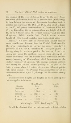
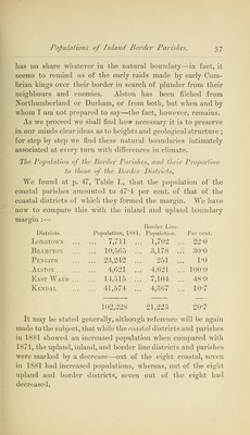
![capable of causing a difference in the climates of two places only a furlong apart.1 The great central water-parting of this district is remark- able not only on account of its great influence on the local climates of the districts on its northern and southern sides, but for its length, height, direction, and geological structure, all of which have most interesting histories, which, however, we must leave for the present. This central water-parting stretches right across the Lake District from west to east; and, without reckoning the curves which occur during its course, its length in a straight line from Dent Hill to Wasdale Pike, is about 32 miles ; the width of the district at this point, namely from St. Bees Head on the west, to the extreme eastern boundary of West Ward, being about 45 miles, so that the ridge occupies all but 13 miles of a line extending through the most central and widest part of the Lake District. Either of the accompanying maps will enable the reader to trace this water-parting if the following instructions are attended to. First, find Ennerdale water in the Whitehaven district, this lake is 369 ft. above sea level; on the east is seen its affluent (the river Liza), which has its source at Green Gable (2,500 ft.), and on the west its effluent (the river Ehen), which at Cleator bends suddenly to the south around the western end of the central water-parting, which culminates in Dent Hill (1,130 ft.), whose position in the map corresponds with the T in Whitehaven : the water-parting then takes a north-easterly direction, but to the south of the river Ehen and Ennerdale water to Grike (1,596 ft.), and then in a south-easterly direc- tion over Iron Crag (2,071 ft.) to Gawfell (2,188 ft.), which mountain lies immediately to the south of the south-east end of Ennerdale Water, at a distance of nearly two miles, pro- 1 7]v koX (rrdStov to fi€Ta£v rjv. Airs, Waters, and Places.—Littre, vol. ii. p. 22. A stadium contains 606 ft. 9 in., or 53 ft. 3 in. less than a furlong (660 ft. 0 in.), and is about an eighth of a mile.](https://iiif.wellcomecollection.org/image/b2102098x_0083.jp2/full/800%2C/0/default.jpg)