Report to the General Board of Health on a preliminary inquiry into the sewerage, drainage, and supply of water, and the sanitary condition of the inhabitants of the hamlet of Hoddesdon and the parish of Broxbourne, in the county of Hertford / by William Ranger, Superintending Inspector.
- William Ranger
- Date:
- 1851
Licence: Public Domain Mark
Credit: Report to the General Board of Health on a preliminary inquiry into the sewerage, drainage, and supply of water, and the sanitary condition of the inhabitants of the hamlet of Hoddesdon and the parish of Broxbourne, in the county of Hertford / by William Ranger, Superintending Inspector. Source: Wellcome Collection.
6/16 page 4
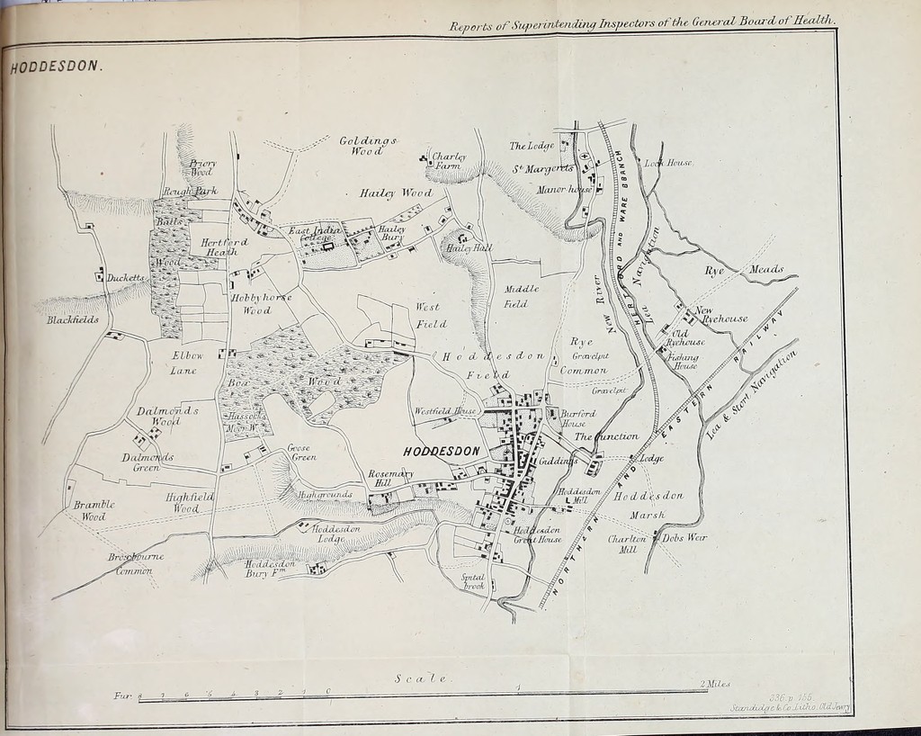
![inspection of the different localities which 1 made, accomp: by the medical officers and other inhabitants of the chapi-1 Hoddesdon, exclusive of Broxbourne, there being, as I before stated, a known or denned boundary to the former ] Hoddesdon, however, includes a portion of Amwell, there houses in the latter parish intermingled with those o chapelry. Position of the Hamlkt.—The hamlet is bounded'1 River Lea on the east, by Broxbourne on the south, Brick on the west, and Amwell on the north. It is clivided int< but unequal, parts by the high road from London to A\ a branch to Stanstead commencing nearly in the middle 11 town. It is also intersected by the New River, which on the northern side, following a tortuous course, and k it on the east. The town itself stands on rather el<< ground above the river. Forasmuch as the A.ct contemplates the adoption of exti boundaries for the purpose of obtaining proper areas anfl falls for drainage, these areas proper are of two cli one has reference to town drainage, the other to wate or gathering ground. And it is one main principle > statute, that districts may, if necessary, be formed s< correspond with the areas of drainage, and co-extensiv the line of water-shed. The hamlet of Hoddesdon and the parish of Broxbour contiguous to the valley of the Lea, its river forming the of a valley in the great chalk ridge which intersects the u of Hertford. The tributaries, consisting of the Mia Beane, Rib, Ash, and the Stort, are under no general c but subject to partial and independent or separate jurisa consisting of— .pit *. The Trustees of the Navigation of the Lea, or partf! river Lea, from Hertford to London, The Commissisoners of the Stort Navigation, The Commissioners of Walthamstow Marshes, The Mill-owners, The Landholders and their tenants. Upon a careful examination of rivers and their tnbu two characteristic differences will be found to present selves : some are subject to sudden floods, while others o, size, and under similar conditions, are not so. The low lands at various parts are subject to peg inundation, so that the upland drainage is impeded tc of a free discharge of its waters, and the soil, as a conseof is rendered far less productive. . The cause, I think, is this : the waters from the uplan no means of discharge ^cept by the narrow bed oj t which may be almost termed neglected ; for although w](https://iiif.wellcomecollection.org/image/b20422301_0010.jp2/full/800%2C/0/default.jpg)