The water supply of Kent : with records of sinkings and borings / by William Whitaker ... with contributions by H. Franklin Parsons ... Hugh Robert Mill ... and J.C. Thresh ... Pub. by order of the lords commissioners of His Majesty's Treasury.
- Whitaker, William, 1836-1925.
- Date:
- 1908
Licence: In copyright
Credit: The water supply of Kent : with records of sinkings and borings / by William Whitaker ... with contributions by H. Franklin Parsons ... Hugh Robert Mill ... and J.C. Thresh ... Pub. by order of the lords commissioners of His Majesty's Treasury. Source: Wellcome Collection.
108/414 page 98
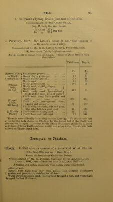
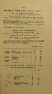
![Charlton. Ordn. Map 271, new ser.; Geol. Maps 1, S.W., London and its Environs, and London District, Sheet 4 (new.) Messrs. Siemens & Co.’s Works, on the Marsh, just W. of the former Woolwich Dockyard. Communicated by Messrs. Siemens. 1 and 2, tube-wells, in Bowater Road, respectively about 170 and 230 feet from the western end of the works, and 8 feet above Ordnance Datum, proved 26| and 37 feet of alluvial beds, and 17-| and 6 of gravel, above Chalk, the upper part soft. 3 to 5 are trial-borings, not for water (see pp. 252, 253). 6 and 7. Abyssinian Tube Wells, afterwards excavated down to gravel. 6 about 70 feet N. of Bowater Road, a little W. of the centre of the works. 7 Northern side of Bowater Road about 520 feet W. of Trinity Street. 9 and 8 feet above Ordnance Datum. Chartham. Kent Asylum, 1874. Ordn. Map 289, new ser.; Geol. Map 3. From a tracing communicated by Mr. J. Giles (Quart. Jouru. Geol. Soc., vol. xlii., p. 35). 254 feet above the level of the Stour. Shaft 261 feet, with two headings each 100 feet long, east and west, at 257 feet, the rest bored. First water-level 231 feet down. Present water-level (? October, 1874), 238 feet down. ? Pumped down 10 feet. About 80,000 gallons a day used. Thickness. Depth. Ft. Ft. White chalk with beds of flints 261 261 Soft chalk with flints 51 312 Black sticky chalk with flints 8 320 White chalk with few flints Hard rocky chalk with veins of 53 373 Upper Middle and Lower Chalk, about 734 feet. pyrites Hard chalk with flints 11 16 384 400 Light-coloured chalk with few flints 60 460 Hard grey chalk with beds of stone Dark sticky chalk, hard in places 44 504 [a specimen from a depth of 607 feet is clayey chalk, rather dark; another from 731 feet, is chalk marl, with green grains; and another, from 732 feet, is the same, with more green grains] ... 230 734 \ Dark sand [base of Chalk Marl] ... 3 — Gault clay [specimens grey and calcareous?] 740 Mr. G. Dowker says : “ From the specimens I have seen at the Can- terbury Waterworks, I doubt if they quite reached the Gault.” (Geol. May., 1887, dec. iii., vol. iv., p. 208.)](https://iiif.wellcomecollection.org/image/b28126737_0108.jp2/full/800%2C/0/default.jpg)