The water supply of Kent : with records of sinkings and borings / by William Whitaker ... with contributions by H. Franklin Parsons ... Hugh Robert Mill ... and J.C. Thresh ... Pub. by order of the lords commissioners of His Majesty's Treasury.
- Whitaker, William, 1836-1925.
- Date:
- 1908
Licence: In copyright
Credit: The water supply of Kent : with records of sinkings and borings / by William Whitaker ... with contributions by H. Franklin Parsons ... Hugh Robert Mill ... and J.C. Thresh ... Pub. by order of the lords commissioners of His Majesty's Treasury. Source: Wellcome Collection.
53/414 page 43
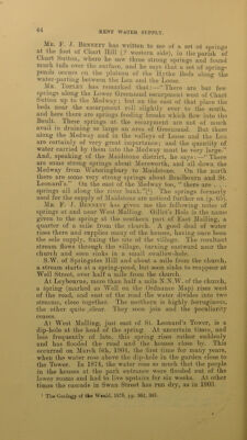
![LOWER GREENSAND. In so permeable a formation, consisting1 chiefly of sand and always with a basal clay, springs must be common, but they have not generally that definite character so usual with springs from the Chalk or other thick limestone. Mr. Topley has remarked : —“ Powerful springs occur in many places; but it is doubtful if these could well be utilised [for supply]. They are largely used by mills.”(x) Where the clayey Sandgate Beds occur the water is thrown out at favourable spots from the overlying Folkestone Beds, but where the former are absent, or so poorly represented as to be unmappable, water may pass through into the Hythe Beds, and then there will be but one set of springs, thrown out by the Atherfield Clay, instead of two sets. But few details can now be given, and the formation will be treated as a whole. The following' account indeed is very far from perfect, and the springs noticed are examples only. The springs thrown out from the Folkestone Beds by the Sandgate Beds have been the cause of the landslips along the coast of Sandgate. At and eastward of Hythe, there are springs from the base of the Hythe Beds or Kentish Pag, and these are used for supply (see pp. 64, 65). Westward from Hythe for several miles, there are like springs which have given rise to the remarkable line of irregular landslip-slope, on part of which the Roman Castle of Lympne has been brought down. Many of these springs are marked on the Ordnance Map (Kent, Sheet 74). Mr. Gr. Dowker notes springs further inland from this ridge at Cheriton, Newington, Saltwood, and Sandling Park and Lympne, but gives no details.(2) One at the last place is marked on the Ordnance Map (Kent, Sheet 74), just north of Coldharbour, about 1^ miles W.N.W. of the village, and the water must be thrown out from the Hythe Beds by the Atherfield Clay. I am indebted to Dr. H. F. Parsons for the following account of some springs in the parish of B^/oughton Malherbe. They occur at Liverton Street (Leperton of old map), half a mile W.N.W. of the church, and rise 'from the base of the Hythe Beds at the junction with the Atherfield Clay. There are four springs, near together, the aggregate yield of which on April 28th, 1898, was 18^ gallons a minute, and on October 7th (a dry season), 12^ gallons. In 1898 the Rural District Council proposed to use these springs for the supply of Headcorn, four miles off, and applied to the Local Government Board for sanction to a loan; but, in the meantime, the South Kent Water Co., in whose area Headcorn is, but whose powers had lapsed, suddenly stepped in and laid mains to Headcorn so the scheme was not proceeded with. '. Rep. R. Comm. Metrop. Water Supply, 1893. Appendices, p. 417. *. Oeol. Mag., 1887, dec. lii., vol. iv., p. 205.](https://iiif.wellcomecollection.org/image/b28126737_0053.jp2/full/800%2C/0/default.jpg)