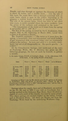
The water supply of Kent : with records of sinkings and borings / by William Whitaker ... with contributions by H. Franklin Parsons ... Hugh Robert Mill ... and J.C. Thresh ... Pub. by order of the lords commissioners of His Majesty's Treasury.
- Whitaker, William, 1836-1925.
- Date:
- 1908
Licence: In copyright
Credit: The water supply of Kent : with records of sinkings and borings / by William Whitaker ... with contributions by H. Franklin Parsons ... Hugh Robert Mill ... and J.C. Thresh ... Pub. by order of the lords commissioners of His Majesty's Treasury. Source: Wellcome Collection.
59/414 page 49
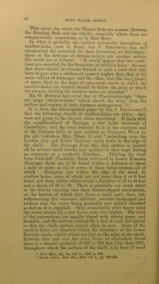
![as it is of water. But on the river-bank near that village a large and perennial spring bursts out. There are, I believe, several other springs in the river, but this is a very striking- one, and is apparently dependent upon the brooks lost in the swallow holes a mile distant on the hills above. Not that I think that the streams are continued underground in separate and independent channels from the spot where they disappear to that at which they issue in the river-bank, but that they descend, within a short distance, through one or more channels down through the mass of the chalk, until they reach the: line [plane] of permanent water-level which passes-under the hills in a curve rising slightly from the river Stour and descending again towards Faversham. The additional supply made by the brooks at this spot determines a higher local level in the water-line, and consequently the springs issue in greater force, and higher above the river,, along the nearest lowest level of the valley. . . The bulk of the springs are probably in the bed of the river, or low on its banks, and are therefore not so apparent.” Eastward and north-eastward of the above set of holes “ from Hatch Green (Chartham Hatch of the newer map) to Dinstead (Denstead Farm) and Fishpond Farm (not named on the newer map, but close to White Wall) there are several other swallow-holes.” I saw one in Howfield Wood, of the old map, included in Bigberry Wood in the newer one, more than half a mile east of Chartham Hatch. Writing of Bigberry Wood, Caft. Me.Dakin remarks that there are some deep holes in the western corner, “ with subterranean streams that may be heard running at the bottom. . . They are from twenty-five to twenty-nine feet deep and they pass through the Thanet-sands for about 25 feet to the chalk.” He holds that the holes have been formed by the subter- ranean stream, apparently anticipating Me. Bennett’s view- (p. 45.) (*) There are swallow-holes at the western foot of the same range of hills, southward of Boughton Street, in the re-enter- ing angles of the boundary of the Thanet Beds at Oversland, and South Street, close to the junction with the Chalk; these receive the water from the high ground eastward. Under ordinary circumstances, the water would break out again from the Chalk lower down the valley; but early in November 1892 heavy rains caused this drainage to overflow in great part, making a mostly continuous watercourse, the water of which betrayed its origin (drainage from the Tertiary beds) by its turbidity. In two places, however, artificial swallow- holes caused local sinking of the water. One of these places was by the roadside just S.E. of South Street, and the other by the roadside just N.W. of the hamlet, where the water was pouring down a hole kept open by a pipe. 1 22, Rep. E. Kent N H. Soc., 1880. D](https://iiif.wellcomecollection.org/image/b28126737_0059.jp2/full/800%2C/0/default.jpg)