The water supply of Kent : with records of sinkings and borings / by William Whitaker ... with contributions by H. Franklin Parsons ... Hugh Robert Mill ... and J.C. Thresh ... Pub. by order of the lords commissioners of His Majesty's Treasury.
- Whitaker, William, 1836-1925.
- Date:
- 1908
Licence: In copyright
Credit: The water supply of Kent : with records of sinkings and borings / by William Whitaker ... with contributions by H. Franklin Parsons ... Hugh Robert Mill ... and J.C. Thresh ... Pub. by order of the lords commissioners of His Majesty's Treasury. Source: Wellcome Collection.
88/414 page 78
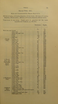
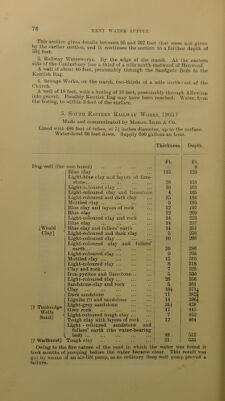
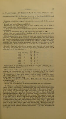
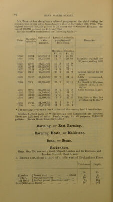
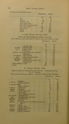
![Mr. Terrill has also given a table of gaugings of the yield during the construction of the adits, from January 21st to November 16th, 1900. The highest amount (430,320 gallons in 24 hours) was on October 17th, and the lowest (78,208 gallons) on February 2nd. He has further contributed the following table :— Date. 1 Rainfall in inches. Gallons of water pumped. 1 Level of water in pumping-well, June 22nd. Remarks. 1893 28-61 38,633,711 Morning. Ft. in. 14 4 Evening. Ft. in. 31 10 1894 38-82 39,309,386 12 7 28 10 Heaviest rainfall for 1895 23-83 41,037,419 15 3 19 9 30 years, ending 1906 1896 29*44 39,673,997 19 11 22 7 1897 27-21 46,245,555 18 3 17 11 1898 22-53 45,548,396 23 1 27 9 Lowest rain fa] 1 for 30 1899 25-86 47,809,520 20 2 21 5 years Adits commenced, 1900 28-1 65,696,073 25 7 30 11 August At D well in this case 1901 23-63 69,782,129 18 2 20 8 surface 10 ft. 2 in. higher Adits finished, Marcfi 1902 23-06 54,736,S93 14 10 17 2 1903 33-19 59,089,049 9 10 12 6 1904 24-03 59,198,530 9 9 12 10 Feb. 29th to Mar. 3rd 1905 27-17 64,709,306 11 7 14 3 overflowing to river* 1906 63,116,737 11 7 16 4 * The morning-level was 2 feet 9 inches and the evening-level 5 feet 6 inches. Besides Ashford parts of Willesborough and Kingsnorth are supplied. There are 1,265 feet of adits. Yearly supply for all purposes 63,116,737 gallons. (Water Works Directory, 1907.) Banning, see East Barming. Banning Heath, see Maidstone. Bean, see Stone. Beckenham. Ordn. Map 270, new ser.; Geol. Maps 6, London and its Environs, and London District, Sheet 4, new. 1. Brickyard, about a third of a mile west of Beckenham Place. Thickness. Depth. Ft. Ft. [London C Loamy clay about 5 5 Clay, j Strong blue clay „ 10 15 16£ feet] (.Pebbly gravel [basement-bed ?] „ H loi Sand [Oldhaven Beds] 18 34|](https://iiif.wellcomecollection.org/image/b28126737_0088.jp2/full/800%2C/0/default.jpg)