Statistical reports on the sickness, mortality, & invaliding, among the troops in Western Africa, St. Helena, the Cape of Good Hope, and the Mauritius / prepared from the records [by A.M. Tulloch, H. Marshall, and T.G. Balfour] of the Army Medical Department and War Office returns.
- Great Britain. Army Medical Services
- Date:
- 1840
Licence: Public Domain Mark
Credit: Statistical reports on the sickness, mortality, & invaliding, among the troops in Western Africa, St. Helena, the Cape of Good Hope, and the Mauritius / prepared from the records [by A.M. Tulloch, H. Marshall, and T.G. Balfour] of the Army Medical Department and War Office returns. Source: Wellcome Collection.
45/128 (page 35)
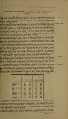
![[ 3a ] On the Sickness and Mortality among Troops serving in the Island of St. Helena. - 1 This Island is situated in the Southern Atlantic, about 2000 miles from the American, and 1200 from the African continent, between 15° and 16° of South Latitude, and 5° and 6° of West Longitude. It is about 10J miles in length, 6f in breadth, and has a superficial extent of above 30,000 acres. When viewed from a distance, it presents only a mass of abrupt rugged rocks, towering to the height of 2700 feet, apparently divested of vegetation, and in several parts broken into immense chasms. On closer inspection, however, it is found to be divided by a lofty chain of hills running in a curved direction from east to west, with several ridges branching oft towards the north and south, and forming valleys of various extent, but all extremely contracted. At the entrance of one of these valleys, on the North-West or Leeward side of the island, is James Town, the capital. This valley extends about two miles inland, where it terminates at the foot of a rock 300 feet in height, over which a small stream falls into a reservoir for supplying the town and shipping with water. On each side of this valley the ground rises with great abruptness into two broken rugged eminences of considerable elevation : that on the west, termed Ladder Hill, is surmounted at the height of 600 feet by a battery, the ascent to which is so steep that it has sometimes to be made by a step ladder; the other is also of a similar precipitous character, conse¬ quently but little vegetation except patches of furze and stunted shrubs can find root, except towards the bottom of the valley. The country becomes less wild and rugged, however, and the luxuriance of vegetation increases in proportion to the distance from the sea; most, of the uplands are covered with verdure, many spots in the interior under rich cultivation, and at an elevation of nearly 1700 feet are two level tracts, called Longwood and Francis Plains, the former of which is upwards of 1500 acres in extent. That part of the island is well wooded, and affords good pasture, a few dwarf trees and shrubs are also scattered over the summits and sides of the high grounds in the interior, but, generally speaking, vegetation is scanty. Various small streams intersect the island, but there is no marshy or swampy ground. Though within 15 degrees of the Line the climate is by no means unhealthy; even Europeans, some time resident there, experience but. little of the debilitating effects so much complained of in other tropical regions. The South-East trade wind affords a steady breeze, which, in these latitudes, is rarely disturbed by storms and gales, and brings with it a canopy of clouds sufficient to afford shelter from the vertical rays and to admit of labour and exercise being carried on with impunity, even during the heat of the day. The temperature is found to vary very materially, according to the nature of the locality and different degrees of elevation. In James Valley, for instance, where the principal part of the troops are quartered, and where the reflection from the surrounding heights tends to aug¬ ment the natural heat, the thermometer during the summer months sometimes rises as high as 85°, and is generally about 80°, but at Plantation House, which enjoys an elevation of 1783 feet, the average at that season is much the same as in Great Britain. The difference between the two stations in this respect, will be seen by the following table for the year 1 §26:— James Town. Plantation House. Months. Average Minimum. Average Maximum. Average Minimum. Average Maximum. January . February March . April May .... June. July .... August . September . October . November . December . o 77 78?- 7Sf 78 75J- 72 69 68 681 704 71 73 o 814 834 83| 82? 794 76? 714 714 71* 73 734 7H 684 72 70? 684 654 634 58* 584 60 62? 634 654 o 72 74? 74 72 681 671 611- 611 634 65? 66* 69? The equality of temperature here indicated by the thermometer is, however, said to be counterbalanced by the circumstance, that, owing to the nature of the localities, a sudden reduction or increase may be experienced in the course of a few minutes: the soldier, for instance, who ascends from James Town to Ladder Hill, exchanges the heat of the tropics for that of a temperate region, and these transitions, particularly after the labour of the ascent, are supposed prejudicial to health. The difference between the high and low grounds in regard to moisture is still more remarkable. In James Valley the climate is very dry; in the upper regions of the interior it is remarkably the reverse ; indeed, on the summits of the hills scarcely a day ever passes 1 B 2 % St. Helena. Physical Aspect. Climate. Temperature.](https://iiif.wellcomecollection.org/image/b30449935_0045.jp2/full/800%2C/0/default.jpg)