[Report 1925] / Medical Officer of Health, East Sussex County Council.
- East Sussex (England). County Council
- Date:
- 1925
Licence: Attribution 4.0 International (CC BY 4.0)
Credit: [Report 1925] / Medical Officer of Health, East Sussex County Council. Source: Wellcome Collection.
15/36 (page 15)
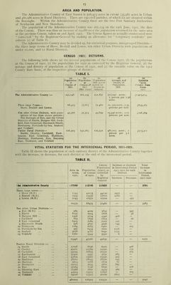
![AREA AND POPULATION. The Administrative County of East Sussex is 516,973 acres in extent (35,987 acres in Urban and 480,986 acres in Rural Districts). There are 152 civil parishes, of which six are situated within the Boroughs. Within the Administrative County there are the two Port Sanitary Authorities of Newhaven and New Shoreham. The population of the Administrative County was 261,234 on the 19th June, 1921, the date of the Census. There was thus an increase of 19,088 over the population returned for the same area at the previous Census, taken on 2nd April, 1911. The Census figures as actually enumerated were “ corrected ” by the Registrar-General by making an allowance for “ temporary residents” (see column (c) of Table I). The Administrative County may be divided up, for statistical purposes, into grouped Districts— the three large towns of Hove, Bexhill and Lewes, ten other Urban Districts with populations of under 10,000, and 12 Rural Districts. CENSUS (1921) RETURNS. The following table shews (a) the several populations of the Census 1911, (b) the populations at the Census of 1921, (c) the populations for 1921 as corrected by the Registrar General, (d) the acreage and density of population at the Census of 1921, and (e) the rateable value on the 1912 County Rate basis, of the respective groups of districts. TABLE I. (a) Population at Census of 1911. (b) Population at Census of ]9l*1, (19th June) (c) Population 1921, as cor- rected by Registrar General. (d) Acreage, and Density of Population, 1921. (e) Rateable Value, County Rau Basis. 1912. The Administrative County :— 242,146 261,234 251.851 517.040 acres; I person per 1.98 acres. £1.915.054 Three large Towns— Hove, Bexhill and Lewes. 68,475 77.665 72,460 10, 579 acres ; 7.35 persons per acre. £643,383 Ten other Urban Districts, with popu- lations of less than 10,000 persons ; The Borough of Rye, and the Urban Districts of Battle, Burgess Hill, Cuck- field. East Grinstead, Haywards Heath, Newhaven, Portslade-by-Sea, Seaford, and Uckfield. 47.366 51.304 49.839 25.446 acres; 2.01 persons per acre. ,^298,369 Twelve Rural Districts— Battle, Chailey, Cuckfield, East- bourne, East Grinstead, Hailsham, Hastings, Newhaven. Rye, Steyning East, Ticehurst, and Uckfield 126,305 132,265 129.552 481,015 acres; i person per 3.6 acres. £973.302 VITAL STATISTICS FOR THE INTERCENSAL PERIOD, 1911-1921. Table II shows the population of each sanitary district of the Administrative County together with the increase, or decrease, for each district at the end of the intercensal period. TABLE II. Area in Acres, 1921. Population at Census of 1911. Census Population (1921), as corrected by Registrar General Increase or decrease in Intercensal Period 1911-1921 for each District. Total Increase in Intercensal Period, I9I I-I92I Increase. Decrease. Tkt Administrative County 617040 242146 251851 — — 9705 Three large towns :— I Hove (M.B.) .. 1543 42173 44150 1977 — 2 Bexhill (M,B.) 7993 15330 17610 2280 — 3 Lewes (M.B.) 1043 10972 10700 — 272 10579 68475 72460 — — 3985 Ten other Urban Districts :— 4 Rye (M.B.) .. 985 4229 3832 — 397 5 Battle 8252 2924 2868 — 56 6 Burgess Hill .. 1496 5124 5540 416 — 7 Cuckfield 863 1899 1873 — 26 8 East Grinstead 6503 7089 7210 I2I — 9 Haywards Heath 928 4851 4996 145 — 10 Newhaven 1184 6665 6460 — 205 11 Portslade-by-Sea 397 6454 7670 1216 — 12 Seaford 3078 4787 6040 1253 — 13 Uckfield 1760 3344 3350 6 — 25446 47366 49839 — — 2473 Twelve Rural Districts :— 14 Battle 37098 6636 6210 — 426 15 Chailey 49961 12769 12590 — 179 16 Cuckfield 54094 16853 16350 — 503 17 Eastbourne 32490 5347 5630 283 — 18 East Grinstead 45809 13007 13530 523 — 19 Hailsham 58062 18045 18290 245 — 20 Hastings 9614 1768 1829 61 — 21 Newhaven 25115 5033 5860 827 — 22 Rye 37264 7146 6830 — 316 23 Steyning East 11568 2891 3453 562 — 24 Ticehurst 45914 13505 12800 — 705 25 Uckfield 74026 23305 26180 2875 — 481015 126305 129552 — — 3247](https://iiif.wellcomecollection.org/image/b29186717_0015.jp2/full/800%2C/0/default.jpg)