Report on the geology of Cornwall, Devon and West Somerset / by Henry T. De La Beche, F.R.S., &c., director of the Ordnance geological survey. Pub. by order of the Lords commissioners of Her Majesty's Treasury.
- Henry De la Beche
- Date:
- 1839
Licence: Public Domain Mark
Credit: Report on the geology of Cornwall, Devon and West Somerset / by Henry T. De La Beche, F.R.S., &c., director of the Ordnance geological survey. Pub. by order of the Lords commissioners of Her Majesty's Treasury. Source: Wellcome Collection.
61/714 (page 23)
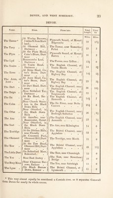
![DEVON. Name. The Tamar * The Tavy The Plym The Lyd The Yealm The Erme The Avon, or Aune . The Dart The Teign The Ex The Culm The Otter The Axe The Yart The Torrid ge The Okement The Taw The Little Dart The Yeo The Bray River The Lyne Rises. At Wooley Barrows,'! 5 miles S. from Hart- > land. . .1 |At Okement Hill, ) \ Dartmoor . . J At the Plym Head, Cater’sBeam, Dart- moor j Branscom.be Loaf, 1 [ Dartmoor . . J } At Erme Head, Ca- ter’s Beam, Dart- moor At Aune Head, Ca ter’s Beam, Dart- moor fAt Dart Head, Dart-) \ moor . . j i Near Siddaford Tor,) ( Dartmoor . . j | At Ex Head, Ex- j j moor . . J {Near Church Staun-1 ton, in the Blaclo Down Hills . j {Near Otterford, in the Black Down Hills At Axnoller, near Beaminster, Dorset {Near Otterford, in the Black Down Hills | At the Ditchen Hills,) t near Clovelly . j At Craumere Pool, Okement Hill,Dart- moor , At the Taw Head, Okement Hill, Dart- moor n Near East Anstey . (Near Chapman Bar-} “ r . J jOnRakenford Moor, \ Rakenford . | rows, Exmoor |On Black Barrow ) 1 Down, Exmoor . j Flows into. Plymouth Sound, at Mount 1 Edgcumbe „ . j The Tamar, near Tamerton) Foliot . . . j Plymouth Sound, at Mount) Batten . . , j The Tamar, near Lifton . The English Channel, at] Yealm Mouth The English Channel, at, Bigbury Bay ’.at} ’. a‘} The English Channel, at) Bigbury Bay . . } The English Channel, near) Dartmouth . . . j The English Channel, at) Teignmouth . . J The English Channel, at) Exmouth . . . j The Ex River, near Stoke Cannon ke} The English Channel, near) Budleigh Salterton . j |The English Channel, near) \ Axmouth . . . j The Axe, near Kilmington The Bristol Channel, near) Appledore . . . j The Torridge, near Meeth The Bristol Channel, near) Appledore . . . J The Taw, near Chumleigh |The Taw, near Newnham) \ Bridge . . . / The Yeo, near Saterleigh The Bristol Channel, at ) Lynmouth . . . j Total Length Miles. 59 23 16 13* 14 14* 23 36 33 54* 25* 26 23 14 53 18 48 15 19 15 11 Tidal for Miles. 17* 3 0 83 2^ 3* 10* 5 7 0 |1* H o 9 0 11* 0 0 0 0 This may almost equally be considered a Cornish river, as it separates Cornwall trom Devon for nearly its whole course.](https://iiif.wellcomecollection.org/image/b29350864_0061.jp2/full/800%2C/0/default.jpg)