[Report 1967] / Medical Officer of Health, Surrey County Council.
- Surrey (England). County Council
- Date:
- 1967
Licence: Attribution 4.0 International (CC BY 4.0)
Credit: [Report 1967] / Medical Officer of Health, Surrey County Council. Source: Wellcome Collection.
52/98 (page 48)
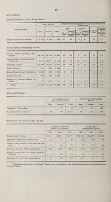
![GENERAL STATISTICS AND SOCIAL CONDITIONS. Area. There have been no changes affecting the Administrative County or the boundaries of the County Districts during the past year and the area of the Administrative County remains at 415,879 acres. Population. [The figures mentioned below for the years 1961-64 are purely for the purpose of comparison and express the populations as they would have appeared if the Administrative County during these years consisted of the same area and districts as it does now as a result of the London Government Act, 1963.] The population of the Administrative County at the 1961 census was 902,078, and the Registrar- General’s estimate of the population at mid-year 1967 was 985,930, an increase of 8,600 over the comparable figure for mid-year 1966. The population under 1 year is given by the Registrar-General as 15,100, the population 1-4 years as 66,500, and the population 5-14 years,'147,300. The Registrar-General’s mid-year estimate of the population for the Urban and Rural areas during each of the five years 1963-1967 is shown in the following table :— 1963 1964 1965 1966 1967 Urban Districts Rural Districts ... 750,090 185,720 764,750 191,160 775,470 192,300 782,470 194,860 789,750 196,180 Administrative County 935,810 955,910 967,770 977,330 985,930 Increase or decrease over previous year ... + 14,550 + 20,100 + 11,860 + 9,560 + 8,600 The following table shows the population of each Sanitary District at the censuses of 1951 and 1961, and the Registrar-General’s mid-year estimates for 1966 and 1967 :— DISTRICTS Area in Acres. Census Population. Registrar-General’s Estimates of Mid-year populations. 1951 1961 1966 1967 M.B. and Urban. 1. Banstead... 12,821 33,529 41,559 42,020 41,950 2. Caterham and Warlingham 8,233 31,293 34,869 36,930 36,910 3. Chertsey ... 9,983 30,852 40,390 44,250 44,710 4. Dorking ... 9,511 20,252 22,604 23,100 23,010 5. Egham 9,350 24,690 30,571 31,350 31,670 6. Epsom and Ewell 8,427 68,055 71,159 72,150 72,320 7. Esher 14,850 51,432 60,610 62,650 62,980 8. Farnham... 9.039 23,928 26,934 29,650 29,840 9. Frimley and Camberley 7,768 20,386 28,552 39,850 40,660 10. Godaiming 2,393 14,244 15,780 17,800 17,810 11. Guildford... 7,323 48,048 53,976 55,200 55,470 12. Haslemere 5,751 12,003 12,523 13,340 13,450 13. Leatherhead 11,187 27,206 35,582 37,740 38,090 14. Reigate ... 10,255 42,248 53,751 55,930 56,340 15. Staines 8,271 39,995 49,259 54,430 55,190 16. Sunbury ... 5,609 23,394 33,403 38,850 39,320 17. Walton and Weybridge... 9,049 38,112 45,510 50,220 51,190 18. Woking ... 15,708 47,596 67,519 77,010 78,840 Total 165,528 597,263 724,551 782,470 789,750 Rural. 1. Bagshot ... 16,083 14,109 16,180 18,120 18,410 2. Dorking and Horley 53,943 25,832 31,710 34,260 34,300 3. Godstone 52,507 32,823 40,225 43,750 44,360 4. Guildford... 59,643 44,936 54,888 62,140 62,030 5. Hambledon 68,175 31,851 34,524 36,590 37,080 Total 250,351 149,551 177,527 194,860 196,180 Administrative County . 415,879 746,814 902,078 977,330 985,930 The figures given by the Registrar-General express the populations for the 1951 Census as they would have appeared if the area boundaries at that time were the same as they are at present. Rateable Value and Estimated Product of a Penny Rate. The rateable value of the Administrative County on the 1st April, 1967, was £52,558,38/, and the estimated product of a Id. rate for general County purposes for the year 1967-68 was £214,446.](https://iiif.wellcomecollection.org/image/b30148844_0052.jp2/full/800%2C/0/default.jpg)