A treatise on waterworks for the supply of cities and towns : with a description of the principal geological formations of England as influencing supplies of water ... / by Samuel Hughes.
- Date:
- 1859
Licence: Public Domain Mark
Credit: A treatise on waterworks for the supply of cities and towns : with a description of the principal geological formations of England as influencing supplies of water ... / by Samuel Hughes. Source: Wellcome Collection.
Provider: This material has been provided by the Royal College of Physicians of Edinburgh. The original may be consulted at the Royal College of Physicians of Edinburgh.
57/394 page 43
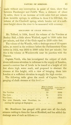
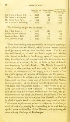
![mow arched over and conducted in culvert?, are said to have '.yielded 1 million gallons per day. Streams and rivers in a chalk district are commonly more .equal and uniform in volume than those in clay districts, and rare not so liable to be swollen by floods as the latter. It is lin consequence of this, and of the more absorbent quality of tthe chalk, that the streams are comparatively much fewer :in chalk districts. Not only are the streams much less in tnumber, but the bridges and culverts made to carry off water iin the chalk districts, present a most insignificant area com- i pared with those in clay districts of similar extent. This fact, 'which I believe was first noticed by the Dean of Westminster, ■was used with very good effect by Mr. Homersham in pre- j paring a sort of popular comparison between districts of clay . on the one hand, and chalk on the other. According to Mr. Homersham's measurements, it was found 1 that the water-way of arches in clay districts varied from 8 to ] 7 superficial feet for each square mile of drainage area, while in > chalk districts the water-way varied from ^rd of a foot to 2 superficial feet per mile of drainage area. Mr. Homersham gives one example, namely, a part of the river Blackwater having a water-way at Coggeshall, in Essex, equal to 3 square feet per mile of drainage area. This, however, is not a fair sample of a clay drainage, as this river flows over a consider- able extent of the crag formation, where it very thinly covers the chalk, and some part of its upper course is even through chalk. Mr. Homersham has similarly quoted against himself the water-way of several rivers whose course is partly in chalk and partly in clay. On a careful review of his table, the least water-way which I can find in a pure clay drainage is about 8 feet per mile, ranging up to 13 and even 17 feet; while the water-way in chalk districts varies from -g^rd to 1^ square feet, except in the case of the river Beane, the drainage area of which contains a large proportion of impermeable drift. In this case, the water-way has an area of 2 square feet per mile of drainage.](https://iiif.wellcomecollection.org/image/b21988092_0057.jp2/full/800%2C/0/default.jpg)