Licence: Public Domain Mark
Credit: Sales catalogue 479: Maggs Bros. Source: Wellcome Collection.
25/928 page 13
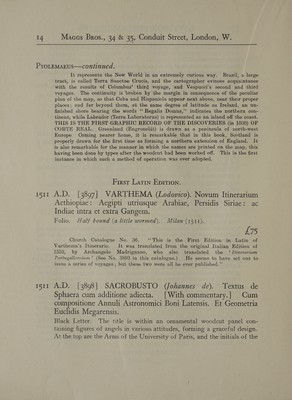
![i ee ee eee te ee \ j Furcosus—continued. special mention is made of his cosmographical studies and on his discussions with other experts in the presence of King Ferdinand as to the possibility of sailing \ westward (from Cadiz). \ “‘ Fregoso, Frigeso, or Campo fuigoso, was the son and brother of a doge, ond himself doge of Genoa (Columbus’ birthplace) from 1479 to 1481.” \ The present edition 1s greatly prized on account of the beauty of the paper and impression.’ WITH THE FIRST PRINTED Map OF ANY PORTION OF THE NortTH AMERICAN CONTINENT. 511 A.D. [3896] PTOLOMAEUS (Claudius). Liber Geographiae cum tabulis et universali fgura et cum additione locorum quae a recentioribus reperta sunt. With 28 woodcut maps on 30 leaves. Printed in red and black on 65 leaves of vellum and 26 leaves of paper, in Roman Letter, double columns, with 60 lines to a full column. Folio. Levant morocco, g. e., by Riviere. Venice, Jacobus Pentius de Leucho, 20th March, I511. (SEE ILLUSTRATION, PLATE No. XIII.). £150 Harrisse, 68. Sabin 66477 Copies printed on vellum are exceedingly scarce. Latin version of Jacobus Angelus, edited with many corrections by Bernardus Sylvanus of Eboli, the principles of which are developed in the introduction. Sylvanus was the first to break with the blind confidence that almost every scholar in the beginning of the 16th century had in the atlas of the old Alexandrian geographer. . . . FOR THE FIRST TIME WE HERE MEET WITH MAPS HAVING THE LETTERPRESS PRINTED IN RED AND BLACK, and contrary to what generally was and yet is the custom, both sides of the paper or vellum are used for the map print, excepting for the new map of the New World, where the reverse is left blank. The maps are from woodcuts, for which the legends are produced by types fitted into blocks. ; The greatest importance of this edition for the history of cartography, con- sists in the cordiform map of the world . . . the first on this projection. THIS IS THE SECOND PRINTED MAP OF THE WORLD, in the delineation of which some attention has been paid to the great geographical discoveries of the preceding years. (This map) ‘‘CONTAINS THE FIRST PRINTED DELINEA- TION OF ANY PORTION OF THE NORTH AMERICAN CONTINENT, under the names of ‘‘Regalis Domus.’ . . . and ‘‘ Terra Laboratorus.’? (Labrador.)](https://iiif.wellcomecollection.org/image/b31659093_0025.jp2/full/800%2C/0/default.jpg)



 No text description is available for this image
 No text description is available for this image
 No text description is available for this image