Report on an investigation as to the housing conditions, with a discussion on their correlation with the chief vital statistics and some notes on town planning / A. G. Anderson.
- Anderson, A. G.
- Date:
- 1911
Licence: In copyright
Credit: Report on an investigation as to the housing conditions, with a discussion on their correlation with the chief vital statistics and some notes on town planning / A. G. Anderson. Source: Wellcome Collection.
Provider: This material has been provided by London School of Hygiene & Tropical Medicine Library & Archives Service. The original may be consulted at London School of Hygiene & Tropical Medicine Library & Archives Service.
177/180 page 151
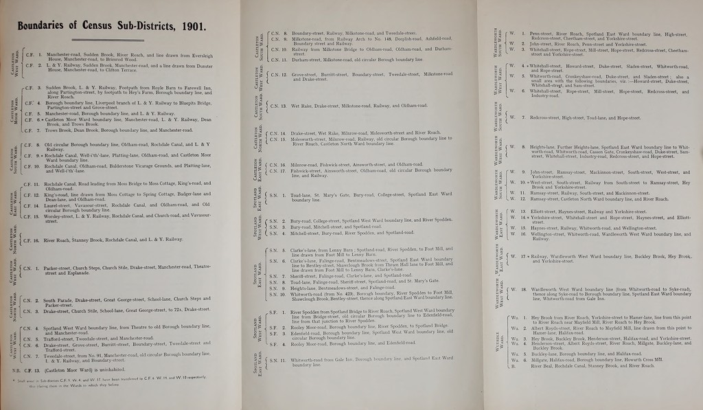
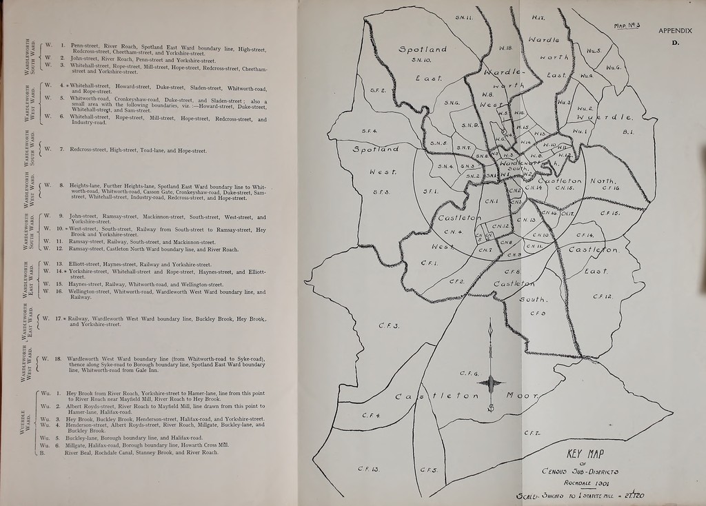
![Boundaries of Census Sub-Districts, 1901. ■ < s CF. 1. Manchester-road. Sudden Brook, River Roach, and line drawn from Eversleigh House, Manchester-road, to Brimrod Wood. CF- 2. L. & Y. Railway. Sudden Brook. Manchester-road, and a line drawn from Dunster House, Manchester-road, to Clifton Terrace. ^C.F. < CF.' 5. CF. c S CF. . CF. Sudden Brook, L. & Y. Railway. Footpath from Royle Barn to Farewell Inn, along Partington-street, by footpath to Hey's Farm, Borough boundary line, and River Roach. Borough boundary line. Liverpool branch of L. & Y. Railway to Bluepits Bridge, Partington-street and Grove-street. Manchester-road. Borough boundary line, and L. & Y. Railway. ' Castleton Moor Ward boundary line, Manchester-road, L. & Y. Railway, Dean Brook, and Trows Brook. Trows Brook. Dean Brook. Borough boundary line, and Manchester-road. < fC-F S. CF. 9. CF. 10. Old circular Borough boundary line, Oldham-road, Rochdale Canal, and L. & Y Railway. Rochdale Canal. Well-i'th'-lane, Platting-lane, Oldham-road, and Castleton Moor Ward boundar*' line. Rochdale Canal, Oldham-road, Balderstone Vicarage Grounds, and Platting-lane. and Well-i'th'-lane. CF. 11. CF. 12. CF. 14. ? I ^ LCF. 15. Rochdale Canal, Road leading from Moss Bridge to Moss Cottage, King's-road, and Oldham-road. King's-road, line drawn from Moss Cottage to Spring Cottage, Badger-lane and Dean-lane, and Oldham-road. Laurel-street. Vavasour-street, Rochdale Canal, and Oldham-road, and Old circular Borough boundary line. Worsley-street, L. & Y. Railway, Rochdale Canal, and Church-road, and Vavasour- street. = ) C.F. 5 z Q I I CN. 1 16. River Roach, Stanney Brook, Rochdale Canal, and L. & Y. Railway. Packer-street, Church Steps, Church Stile, Drake-street, Manchester-road, Theatre- street and Esplanade. < f CN. 2. ; -i 7. C\. 4. CN. 5. ■! CN. 6. South Parade, Drake-street, Great George-street, School-lane, Church Steps and Packer-street. Drake-street, Church Stile, School-lane, Great George-street, to 72.A, Drake-street. Spotland West Ward boundary line, from Theatre to old Borough boundary line, and Manchester-road. Trafford-street, Tweedale-street, and Manchester-road. Drake-street, Grove-street, Burritt-street, Boundary-street, Tweedale-street and Trafford-street. Tweedale-street, from No. 91, Manchester-road, old circular Borough boundary Ime, L & Y. Railway, and Boundary-street. N.B. CF. 13. (Castleton Moor Ward) is uninhabited. CP.** V\».4 andW 17 have be tn Ihc Wards lo which ihcy belui •anifsrrH lo C F, 6 W. 11, and W, 10 tespecliwly. S S C.N. 9. J; a ^ C.N. 10. o g I C.N. 11. z § £S \ C.N. 12. -I z § S ^ ] CN. 13. u o Boundary-street, Railway, Milkstone-road, and Tweedale-streei. Milkstone-road, from Railway Arch to No. 148, Deephsh-road, Ashfield-road, Boundary street and Railway. Railway from Milkstone Bridge to Oldham-road, Oldham-road, and Durham- street. Durham-street, Milkstone-road, old circular Borough boundary line. Grove-street, Burritt-street, Boundary-street, Tweedale-street, Milkstone-road and Drake-street. Wet Rake, Drake-street, Milkstone-road, Railway, and Oldham-road. z 3 r C.N. 14 a j CN. 15, ( CN. 16, [ C.N. 17. || \ S.N. 1. z a Drake-street, Wet Rake, Milnrow-road, Molesworth-street and River Roach. Molesworth-street, Milnrow-road, Railway, old circular Borough boundary line to River Roach, Castleton North Ward boundary line. Milnrow-road, Fishwick-street, Ainsworth-street, and Oldham-road. Fishwick-street, Ainsworth-street, Oldham-road, old circular Borough boundary line, and Railway. Toad-lane, St. Mary's Gate, Bury-road, College-street, Spotland East Ward boundary line. S.N. 2 S.N. 3. S.N. 4. S.N. 5. S.N. 6. S.N. 7. S.N. 8. S.N. 9. S.N. 10. 0 « z < S.F. 2. Spo- West S.F. 3. S.F. 4. rLAND Ward. ' S.N. 11. O H l/) < w Bury-road. College-street, Spotland West Ward boundary line, and River Spodden. Bury-road, Mitchell-street, and Spotland-road. Mitchell-street, Bury-road, River Spodden, and Spotland-road. Clarke's-lane, from Lenny Barn ; Spotland^oad, River Spodden, to Foot Mill, and line drawn from Foot Mill to Lenny Barn. Clarke's-lane, Falinge-road, Bentmeadows-street, Spotland East Ward boundary line to Bentley-street, Shawclough Brook from Thrum HaU lane to Foot Mill, and line drawn from Foot Mill to Lenny Barn, Clarke's-lane. Sheriff-street, Falinge-road, Clarke's-lane, and Spotland-road. Toad-lane, Falinge-road, Sheriff-street, Spotland-road, and St. Mary's Gate. Heights-lane. Bentmeadows-street, and Falinge-road. Whitworth-road (from No. 423), Borough boundary. River Spodden to Foot Mill, Shawclough Brook, Bentley-street, thence along Spotland East Ward boundary Ime. River Spodden from Spotland Bridge to River Roach, Spotland West Ward boundary line from Bridge-street, old circular Borough boundary line to Edenfield-road, line from that junction to River Spodden, Rooley Moor-road, Borough boundary line. River Spodden, to Spotland Bridge. Edenfield-road, Borough boundary line, Spotland West Ward boundary line, old circular Borough boundary line. Rooley Moor-road, Borough boundary line, and Edenfield-road. Whitworth-road from Gale Inn, Borough boundary line, and Spotland East Ward boundary hne. W. L Penn-street, River Roach, Spotland East Ward boundary line, High-street, Redcross-street, Cheetham-street, and Yorkshire-street. W 2. John-street, River Roach, Penn-street and Yorkshire-street. W. 3. Whitehall-street, Rope-street, Mill-street, Hope-street, Redcross-street, Cheetham- street and Yorkshire-street. W. 4. * Whitehall-street, Howard-street, Duke-street, Sladen-street, Whitworth-road, and Rope-street. W. 5. Whitworth-road, Cronkeyshaw-road. Duke-street, and Sladen-street; also a small area with the following boundaries, viz. :—Howard-street, Duke-street, Whitehall-stregt, and Sam-street. W. 6. Whitehall-street, Rope-street, Mill-street, Hope-street, Redcross-street, and Industry-road. 7. Redcross-street, High-street, Toad-lane, and Hope-street. Heights-lane, Further Heights-lane, Spotland East Ward boundary line to Whit- worth-road, Whitworth-road, Casson Gate, Cronkeyshaw-road, Duke-street, Sam- street, Whitehall-street, Industry-road, Redcross-street, and Hope-street. ' W. 9. John-street, Ramsay-street, Mackinnon-street, South-street, West-street, and Yorkshire-street. W. 10. West-street, South-street, Railway from South-street to Ramsay-street, Hey Brook and Yorkshire-street. W. 11. Ramsay-street, Railway, South-street, and Mackinnon-street. . W. 12. Ramsay-street, Castleton North Ward boundary line, and River Roach. W. 13. Elliott-street, Haynes-street, Railway and Yorkshire-street. W. 14.* Yorkshire-street, Whitehall-street and Rope-street, Haynes-street, and Elliott- street. 1 W. 15. Haynes-street, Railway, Whitworth-road, and Wellington-street. W 16. Wellington-street, Whitworth-road, Wardleworth West Ward boundary line, and I Railway. J Railway, Wardleworth West Ward boundary line, Buckley Brook, Hey Brookr and Yorkshire-street. Wardleworth West Ward boundary line (from Whitworth-road to Syke-road), thence along Syke-road to Borough boundary line, Spotland East Ward boundary line, Whitworth-road from Gale Inn. ' Wu. 1. Hey Brook from River Roach, Yorkshire-street to Hamer-lane, line from this point to River Roach near Mayfield Mill, River Roach to Hey Brook. Wu. 2. Albert Royds-street, River Roach to Mayfield Mill, line drawn from this point to Hamer-lane, Halifax-road. Wu. 3. Hey Brook, Buckley Brook, Henderson-street, Halifax-road, and Yorkshire-street, i Wu. 4. Henderson-street, Albert Royds-street, River Roach, Millgate, Buckley-lane, and Buckley Brook. Wu. 5. Buckley-lane, Borough boundary line, and Halifax-road. Wu. 6. Millgate, Halifax-road, Borough boundary hne, Howarth Cross M31. , B. River Beal, Rochdale Canal, Stanney Brook, and River Roach.](https://iiif.wellcomecollection.org/image/b21364308_0177.jp2/full/800%2C/0/default.jpg)