[Report 1904] / Medical Officer of Health, Salop / Shropshire County Council.
- Shropshire Council
- Date:
- 1904
Licence: Attribution 4.0 International (CC BY 4.0)
Credit: [Report 1904] / Medical Officer of Health, Salop / Shropshire County Council. Source: Wellcome Collection.
60/100 (page 40)
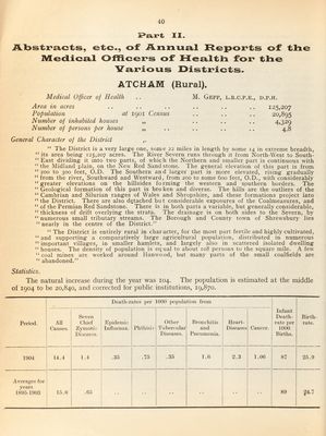
![II. ilLl3str*£iiCts, etc., of Anixua.! Rcpoi^ts of the IMEedicsiil OffiGeK*s of Hesiltlx foi* the V'a.r'ious l>ist]c*icts. ATCHAM (Rural). Medical Officer of Health .. M. Gepp, l.r.c.p.e., Area in acres Population at igoi Census Ntimher of inhabited houses „ Number of persons per house „ D.P.H. 125,207 20,895 4.329 4.8 General Character of the District “ The District is a very large one, some 22 miles in length by some 14 in extreme breadth, “ its area being 125,207 acres. The River Severn runs through it from North-West to South- “ East dividing it into two parts, of which the Northern and smaller part is continuous with “the Midland plain, on the New Red Sandstone. The general elevation of this part is from “200 to 300 feet, O.D. The Southern and larger part is more elevated, rising gradually “ from the river. Southward and Westward, from 200 to some 600 feet, O.D., with considerably “greater elevations on the hillsides forming the western and s.outhern borders. The “Geological formation of this part is broken and diverse. The hills are the outliers of the “ Cambrian and Silurian ranges of Wales and Shropshire, and these formations project into “the District. There are also detached but considerable exposures of the Coalmeasures, and “ of the Permian Red Sandstone. There is in both parts a variable, but generally considerable, “ thickness of drift overlying the strata. The drainage is on both sides to the Severn, by “ numerous small tributary streams. The Borough and County town of Shrewsbury lies “ nearly in the centre of the District.” “The District is entirely rural in character, for the most part fertile and highly cultivated, “ and supporting a comparatively large agricultural population, distributed in numerous “ important villages, in smaller hamlets, and largely also in scattered isolated dwelling “ houses. The density of population is equal to about 108 persons to the square mile. A few “ coal mines are worked around Hanwood, but many parts of the small coalfields are “ abandoned.” Statistics. The natural increase during the j^ear was 104. The population is estimated at the middle of 1904 to be 20,840, and corrected for public institutions, 19,870. Period. Death-rates per 1000 iiopiilatioii from Infant Death- rate per 1000 Births. Birth¬ rate. All Causes. Seven Chief Zymotic; Diseases. E])idemic Influenza. Phthisis Otiicr Tubercular Diseases. Bronchitis and Pneumonia. Heart- Diseases Cancer. 1904 14.4 1.4 .35 .75 .35 1.0 2.3 1.00 87 25.9 Averages for years 1895-1903 15.0 .05 89 g4.7](https://iiif.wellcomecollection.org/image/b30086450_0060.jp2/full/800%2C/0/default.jpg)