[Report 1904] / Medical Officer of Health, Salop / Shropshire County Council.
- Shropshire Council
- Date:
- 1904
Licence: Attribution 4.0 International (CC BY 4.0)
Credit: [Report 1904] / Medical Officer of Health, Salop / Shropshire County Council. Source: Wellcome Collection.
68/100 (page 48)
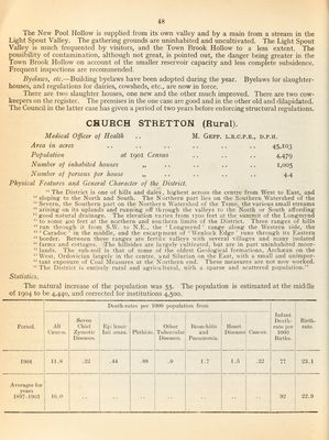
![The New Pool Hollow is supplied from its own valley and by a main from a stream in the Light Spout Valley. The gathering grounds are uninhabited and uncultivated. The Light Spout Valley is much frequented by visitors, and the Town Brook Hollow to a less extent. The possibility of contamination, although not great, is pointed out, the danger being greater in the Town Brook Hollow on account of the smaller reservoir capacity and less complete subsidence. Frequent inspections are recommended. Byelaws, etc.—Building byelaws have been adopted during the year. Byelaws for slaughter¬ houses, and regulations for dairies, cowsheds, etc., are now in force. There are two slaughter houses, one new and the other much improved. There are two cow- keepers on the register. The premises in the one case are good and in the other old and dilapidated. The Council in the latter case has given a period of two years before enforcing structural regulations. CHURCH STRETTON (Rural). Medical Officer of Health .. M. Gepp. l.r.c.p.e., d.p.h. Area in acres .. .. .. .. .. .. 45,103 Population at igoi Census .. .. .. 4,479 Number of inhabited houses ,, .. .. .. .. 1,005 Number of persons per house „ .. .. .. .. 4.4 Physical Features and General Character of the District. “ The District is one of hills and dales, hig-hest across the centre from West to East, and “sloping to the North and South. The Northern part lies on the Southern Watershed of the “ Severn, the Southern part on the Northern Watershed of the Teme, the various small streams “arising on its uplands and running oft through the valleys to the North or South affording “good natural drainage. The elevation varies from 1700 feet at the summit of the Longmynd “to some 400 feet at the northern and southern limits of the District. Three ranges of hills “ run through it from S.W. to N.E., the ‘ Longmynd ’ range along the Western side, the “ ‘ Caradoc ’ in the middle, and the escarpment of ‘ Wenlock Edge’ runs through its Eastern “border. Between these ranges are fertile valleys with several villages and many isolated “farms and cottages. The hillsides are largely cultivated, but are in part uninhabited moor- “ lands. The sub-soil is that of some of the oldest Geological formations, Archaean on the “ West, Ordovician largely in the centre, and Silurian on the East, with a small and unimpop “ tant exposure of Coal Measures at the Northern end. These measures are not now worked. “The District is entirely rural and agricultural, with a sparse and scattered population.” Statistics. The natural increase of the population was 55. The population is estimated at the middle of 1904 to be 4,440, and corrected for institutions 4,500. Death-rates ])er 1000 population from Period. All Caus3.s. Seven Chief Zymotic Diseaso.s. E])i lemic lull lenza. Phthisis. Other Tubercular Di.seases. Bronchitis and Pneumonia. Heart Diseases Cancer. Infant Death- rate iier 1000 Births. Birth¬ rate. 1904 11.8 22 .44 .88 .0 1.7 1.5 .22 77 23.1 Av'cragos for year.s 18!)7-190:? 02 22.9](https://iiif.wellcomecollection.org/image/b30086450_0068.jp2/full/800%2C/0/default.jpg)