[Report 1904] / Medical Officer of Health, Salop / Shropshire County Council.
- Shropshire Council
- Date:
- 1904
Licence: Attribution 4.0 International (CC BY 4.0)
Credit: [Report 1904] / Medical Officer of Health, Salop / Shropshire County Council. Source: Wellcome Collection.
96/100 (page 76)
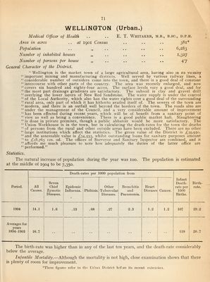
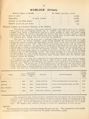
![WENLOCK (Urban). Medical Oljiccr of Health Area in acres Population at 1901 Census Number of inhabited houses „ Number of persons per house „ M. GePP, L.R.C.P.E., D.P.H. 22,657 15,866 3,568 4.4 Physical Features and General Character of the District. “ The District comprises 22,657 acres, being: the largest Borough in Area in the country. “ This area is of very irregular outline, but is, roughly, some ten miles long in greatest “ length, from North to South-West, and has a mean breadth of some four miles, being “ narrowest where the Severn, traversing the District from West to East, makes a natural “ division, the part lying to the South of the river having three or four times the area of “ the northern part, though with less than half the population. “ The District is for the most part a tableland lying at an elevation of from 400 to 600 “feet or more; the Severn forming a deep cutting through this elevated land, its banks “ rising very steeply on either side from about 150 feet, O.D., at the water level to the general “ height of about 500 feet, O.D. The Central and Eastern part, nearly half the area, lies “ upon the coal measures. To the West the formation is the Wenlock and Ludlow beds of “ Silurian age, forming a considerable part of the Southern Division, and extending also to a “ limited extent across the river into the Northern division. Much of this ground lies in “ ridges with intervening valleys at a height of from 600 to 800 feet, O.D. At the Southern “extremity the Old Red Sandstone occurs. The natural drainage is to the Severn, by small “ streams falling as a rule steeply into the. river within the District, but the Southern part “ of the Southern area drains to the South by small streams which meet the Severn some “ distance outside the District. “The District is in large part industrial, the chief industries being coal and iron mining, “ iron manufactures, and brick and tile works. There is also a large china factory. These “ industries are confined to the Northern area together with a small part of the Southern area “ near the river. The greater part of the Southern area is entirely rural and agricultural, and “ thinly populated. For purposes of local administration the Borough is divided into four “ wards, each having a separate Sanitary Committee acting as the Sanitary Authority. These “wards, with their area, population and general character, are as follows: — Ward. Area in Acres. Estimated Population 1904. Situation. General Character. Death- rate per 1000, 1904. Madeley 2481 8445 North of Severn Urban and Industrial, Coal and Iron .. 17.3 Bro.seley 1991 3910 South of Severn Urban and Industrial, Brick and Tile.. 17.6 Much Wenlock 87 (il 2240 South of Severn Agricidtural 17.4 Barrow 9004 1299 Both sides of Severn Agricultural 13.1 “ The populations here given arc those estimated and corrected by the proportioned dis- “ tribution of the population of the Madeley Workhouse and by addition of a proportion of the “ inmates of the County Asylum, the deaths in these institutions being also distributed in the “ several wards. Not riiuch significance should be attached to the death-rates for a single “ year. The figures may, however, become of value for comparison as years go by.” Statistics. The natural increase of the ]topulation during the year was 150. The population at the middle of 1904 is estimated at 15,894, and corrected for public institutions, 15,900.](https://iiif.wellcomecollection.org/image/b30086450_0096.jp2/full/800%2C/0/default.jpg)