[Report 1954] / Medical Officer of Health, Luton County Borough.
- Luton (England). County Borough Council.
- Date:
- 1954
Licence: Attribution 4.0 International (CC BY 4.0)
Credit: [Report 1954] / Medical Officer of Health, Luton County Borough. Source: Wellcome Collection.
38/124 page 34
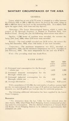
![SANITARY CIRCUMSTANCES OF THE AREA GENERAL Luton, which has an area of 8,773 acres, is situated in a valley between the Chiltern Hills at 200 to 400 feet above sea level in the town, rising to 400 to 600 feet above sea level on the surrounding hills. It is mainly built upon the upper chalk, with loam and clay deposits. Meteorology.-—The Luton Meteorological Station, which is under the control of the Borough Engineer, is situated in Wardown Park, New Bedford Road. During the year the following observations were taken :— Sunshine.—1,240 hours of sunshine were recorded, the sunniest day being 23rd June, 1954, when 12*9 hours were recorded. Rainfall.—-The total rainfall recorded was 29.35 inches, the wettest day being 8th December, ] 954, when 1 -64 inches of rain were recorded. Temperatures.—The maximum temperature was 83' F., recorded on 1st September, 1954, and the minimum temperature was 12°F., recorded on 2nd February, 1954. The mean temperature for the year was 47-92°F. Wind.—The prevailing wdnd was South-West. WATER SUPPLY 1953 1954 million million gallons gallons (1) Estimated total consumption for the Borough —whole year 1,855 1,980 (2) Estimated domestic consumption for the Borough—whole year ... (3) Estimated industrial consumption for the 1,025 1,138 Borough—whole year ... 830 842 (4) Average chlorination ... 0.25p.p.m. 0.25 p.p.m. With a population of 112,500, the total number of gallons used per head per day was approximately 48, an average of 28 gallons per head per day for domestic use, and 20 gallons per head per day for industrial purposes. The following additional information has been supplied by the Luton Water Company. Resources “ The abstraction from the Lee Valley has been reduced since the 26th March, 1954, when Friars Wash Pumping Station commenced produc¬ ing water for consumption. This has allowed abstraction at Crescent Road and Runley Wood Pumping Stations to be reduced to approximately their estimated safe yield.](https://iiif.wellcomecollection.org/image/b29746991_0038.jp2/full/800%2C/0/default.jpg)