Volume 1
Survey of the river Tees.
- Great Britain. Water Pollution Research Board
- Date:
- 1931-1937
Licence: Public Domain Mark
Credit: Survey of the river Tees. Source: Wellcome Collection.
95/112 (page 83)
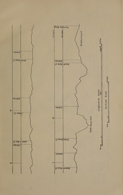
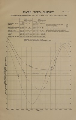
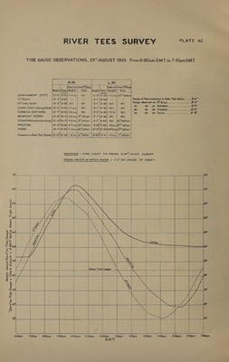
![@= Chart Datum = 8:40Ff! below Mean Tide Level. PLATE: 4] GOVERNMENT JETTY CARGO FLEET/Graving Dock) FURNESS SHIP-YARD NEWPORT FERRY PRESTON YARM Sp Predicted in Adm. Tide Tables L.W. | Hw. [ Interval From 5*Buoy | Interval from 1 5 Buoy peight Time. {Height.| Time _ Height Time | [Height | Time _ Fi 1443 | 6- =O) +lins | Nil 2’-2 |12-50! +2 ins |5™ after | | | | ty oo” ber lest ae Nl | eauiasl sq do POTD SOCK Nano a ie lire'n none eid oe 14°3” | 6-50) + | pio VW 2-45) = tins) Nit kis WIM. <ccien duke ee GU” 14°5| 6-55) +3 ins| 5Tafter |. 9-417] 12-45) - tins}. Nil | do i, cree Ch) 7 ae ee 5g 14°6| 7-00) +4 ins HOT after | 1/10) 12-45) -2ins| Nil |#Mam) observed at S% Buoy 620am. “Height [ares 14/8°16-50! +6 ins} Nil | 144) 12-50] —1 ins|5Tafter [do do predicted in Adm Tide Tables 6:24am Height IS-2FF 14.6| 7-25] + 6 ins |35™ after | 4/9”| 2-40|+2-9 IN 55alter| 14:10) 7-50) + 8 ins |1 after | 941 | 4-40) +7°1 ai 55after oi See ee ee ——— i 14-5f) 7-06, +4 ins | 16 after 2.36/12-5a] +35 ins! 9 after | ae 8 ex “Zero” on Tide Gaug Z30am. a 630am. IDam. a 2 2:30 p.m | iret 6:30pm. ats 7-30p.m. 4.30pm. 5.30pm. 6:30pm.](https://iiif.wellcomecollection.org/image/b32179595_0001_0095.jp2/full/800%2C/0/default.jpg)