Volume 1
Survey of the river Tees.
- Great Britain. Water Pollution Research Board
- Date:
- 1931-1937
Licence: Public Domain Mark
Credit: Survey of the river Tees. Source: Wellcome Collection.
96/112 (page 84)
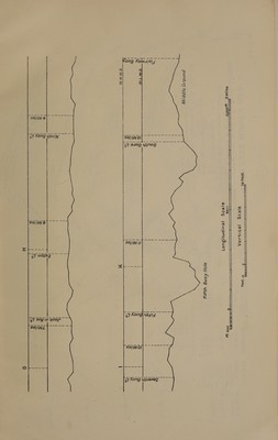
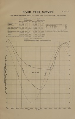
![-40f* below Mean Tide Level. ~ Dp H.W. LW. Interval from 5Buoy ie linterval from 54'Bu Hei ght alee Height [Time [Height Time. Height) Time _ GOVERNMENT JETTY jis-e 9-55|+ 3ins.| Nil | 5-2 4-20} + tins} 20™ before : At 5™ BUOY Ee Spal: eS a4 5-1|4-40| - a | Range oe in Adm. Tide Tables _____- a 10 GAS BUOY 113'-5| 9-55! Nil Nil | S-1|4-40| Nil Nil Range Sbeerved OO S0Cy 7 aa aa ee : : do do do Stockton_..-...--2=-.--- 89 CARGO FLEET (Graving Dock) |\3'-6| 9-55} + tins.| Nil 5'-1|4-40] Nil Nil we cb “tele Prextcnue te 812 FURNESS SHIP-YARD 13'-7|9-55|+2ins| Nil 5-2|4-40| +Tin.| Nil a, é “do Yorn eS NEWPORT FERRY’ 13'-8/10-0| +3 ins| 5 after 4-40) Nil Nil | STOCKTON /(Gorporation Quay) i3'-10'|10-0) + Sins, 5T after 4-25| Nil |I5Tbefore j PRESTON 14'-0|10-30| +7 ins| 357 after | 5-101 5-55) +9ins. 4 after | YARM 14+4110-35| + ilins.|40™after | 10-0 B-30}haFtii 4 after | Predicted in Adm.Tide Tables EaheS -2ins| Iafter | 4-9FF #4i| dina. IT after ISft e a . ae. A ¥ Be sft | | i | al) 114° | aa. : Bile be 5 We ae teft bes | ft ~ = “Zero”on Tide Gauge = Chart Datum = 8 6&30am. 7-30a.m. 8:30a.m. 2:30a.m. 10°304.m, 30am, 2:30pm. G.M.T. 1:30pm. 2:30pm. 4:30pm,](https://iiif.wellcomecollection.org/image/b32179595_0001_0096.jp2/full/800%2C/0/default.jpg)