Report on the medical topography and statistics of Neilgherry Hills / Compiled from the records of the Medical Board Office.
- Madras State
- Date:
- 1844
Licence: Public Domain Mark
Credit: Report on the medical topography and statistics of Neilgherry Hills / Compiled from the records of the Medical Board Office. Source: Wellcome Collection.
12/70 page 2
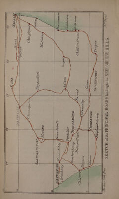
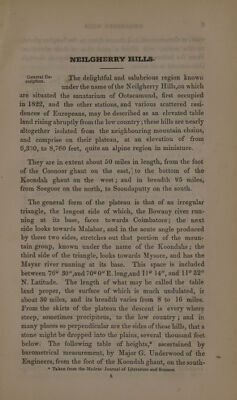
![west, to Ootacamund, and thence down to the Seegoor ghaut, on the north, will afford a good idea of their elevation. From the bottom of the Koondah ghaut to Seegoor, through Ootacamund is 43 miles. Table of heights above the level of the Sea. (Bambe bottom of the Koondah Ghaut............... 893) s [ Bambooe bepinriumiaantekl 10. mate ikase. A 1757 | 3 © J-Ladder Hill, bottom off 00 .se.hm sins aactioe weds «bbe 2972 | $3 8 ‘\ Vullycand Camp, top of ridge....... Pr ss siaysek Ela 4140 | >3 iit WVinllyaur ‘river ac J plier Be waa sonata . 4050 Les Murraypett: bungalow: ...5.. iit Pek, se cteplmwneaiten 6742 23 2 é ze) af Avalanche ridge; topiohs 1/322 Sat. das). LSisied . 7732 E a Si parang bungalow, at bottom of ridge...,......... 6720 J hes < R Ootacamund lake, level of.........5..0.0 0.0000 seces 7361 » {Blink Bonnie, 4 miles from Ootacamund, top of New 3; Seegoat glinutie! <i siliay OO. faoe ae (0G 38 Sapperpoorum, 1 mile below. ..... ..............- 6758 | 3 po | Stonehenge, about 2 miles down.................. . 6182] 5 ~ | Red Hill below Killhutty, Burgher village about 3 miles FI 4 Breast : 5940 | g Waterfall point, proposed site for travellers bungalow, a 5538 S$ g about 4 miles down and 8 from Ootacamund.. ... 8 = < Adam’s peak, north end of large basin, about 43 miles 4982 7 = mig: GLOW 9 ogo walt hac bit Oa Aiic e cte a ia 5 $e Giant’s glen, about o mites GOWN... os. cess een tele ees 4296 | 3 “| Tent mydan, about 4 miles...........+...-.. Hn EK 4001 | & fa a z° Bamboos cease here. 5 8 z & | Large nullah bottom of ghaut...............0 -- seen. 3408 Po) | Seegouk? A BET, ON ee nee eae, SR Mees cae ee 3393 § The general configuration of the hills on the Neilgherry table land, is characteristic and peculiar. They are of various heights from one or two hundred feet, to upwards of 1,400 which is the elevation of the highest peak, that of Dodabet, above the level of the Ootacamund lake. They are universally of a rounded form and outline, rarely broken by asperities or projecting rocks, and are covered with a close thick turf. The base of one hill rises close to that of another, leaving but a small interval between, so that a true valley is very rare, and a level surface of any extent, almost unknown. Itis difficult to find appropiate terms to convey an accurate description of these singularly smooth, rounded and undulating hills; they present truly a “ surg-](https://iiif.wellcomecollection.org/image/b29346885_0012.jp2/full/800%2C/0/default.jpg)

 No text description is available for this image
 No text description is available for this image
 No text description is available for this image