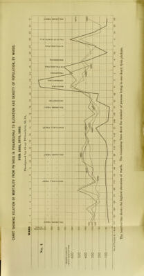
A contribution to the climatological study of phthisis in Pennsylvania.
- William Pepper
- Date:
- 1887
Licence: Public Domain Mark
Credit: A contribution to the climatological study of phthisis in Pennsylvania. Source: Wellcome Collection.
Provider: This material has been provided by Royal College of Physicians, London. The original may be consulted at Royal College of Physicians, London.
17/96 page 3
![taiice to the community, and the great difficulty of obtaining accu- rate data even with the most cheerful and courteous co-operation of the profession. The ]iresent address is to be regarded only as the first crude and imperfect result of an investigation, which I liopc to be able to continue to a much greater degree of completeness. It may not be without interest to give a short account of the physi- cal characters of the area under consideration, in the preparation of which liberal use has been made of a highly interesting report on the topography of Pennsylvania, which was courteously wiitteii at my solicitation by Charles A. Ashburner, Esq., M. S., geologist in charge of the Geological Survey of Pennsylvania. The State of Pennsylvania measures from east to west 290 miles; from north to south, 150 miles; having an area of over 45,000 square miles. It is a distinctly mountainous State. The Alleghany and Blue Ridge Mountains course diagonally through the central portion from the northeast corner to the southwest; upon the one side the drain- age is toward the Atlantic seaboard, and upon the other toward the valley of the Mississippi. Professor Lesley has suggested a topographical division of east- ern Pennsylvania into the Southeastern or the Seaboard district, and the Middle or Appalachian district. The former is bounded on the west and northwest by the Kitta- tinny or North Mountain. The latter is bounded on the southeast by the Kittatinny Mountain and on the north by the escarpment of the Alleghany Mountains. The vallej of the southeastern district is underlain by the lower silurian limestone, forming rich, fertile soils, and, in the northwestern part of the district, by soils disintegrated from the Hudson River States and shales. The Appalachian district of the eastern part of the State has been subdivided by Professor Lesley into the (1) Catskill or Pocono wil- derness at its eastern end, (2) Anthracite Coal Region, (3) the open country of the middle Susquehanna, and (4) the mountains of the Juniata country, in the heart of which lies the Broad Top coal-basin. The Pocono division is the continuation of the Catskill Mount- ains in New York southward into northeastern Pennsylvania em- braced within the counties of Wayne, Pike, Monroe, and Lacka- wanna, and may be said to practically end in the Nesquehoning Mountain west of the Lehigh River. The northwestern part of this division, lying to the east and south of the eastern end of the Wyoming-Lackawanna Valley, consists primarily of an elevated pla- teau cut through by numerous streams running in many instances](https://iiif.wellcomecollection.org/image/b28270538_0019.jp2/full/800%2C/0/default.jpg)