Reports on mountain and marine sanitaria : medical and statistical observations on civil stations and military cantonments., jails - dispensaries - regiments - barracks, &c. within the Presidency of Madras, the Straits of Malacca, the Andaman Islands, and British Burmah from January 1858 to January 1862 / by Duncan Macpherson.
- MacPherson, Duncan, M.D., 1812-1867.
- Date:
- 1862
Licence: Public Domain Mark
Credit: Reports on mountain and marine sanitaria : medical and statistical observations on civil stations and military cantonments., jails - dispensaries - regiments - barracks, &c. within the Presidency of Madras, the Straits of Malacca, the Andaman Islands, and British Burmah from January 1858 to January 1862 / by Duncan Macpherson. Source: Wellcome Collection.
283/458 page 235
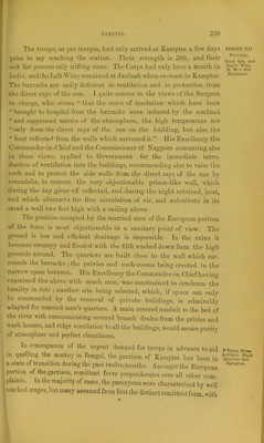
![NAGPOKE. That part of Central India denominated the Berar Division, or the old province of the Deccan, is now sub-divided ; part forming the domi- nions of the Nizam, part the Nagpore territory, and part forming a portion of the Bombay Presidency. It is situated between latitude 20° and 21° north, longitude 76° and 79° east. The province of Nagpore is somewhat triangular in form ; it extends between latitude 18° and 23® north, and longitude|78° and 83° east, the base being towards the Saugor and Dinapore Divisions on the north, and the sides towards the Hyderabad territories, and the northern country of Orissa on the south-east and west. Its estimated area is 26,700 square miles, and its population about 4,000,000. Its northern part is a high table-land, from whence the surface slopes southward to the plain, watered by the Payne Gunga, the Wyne Gunga, the Wurda and Gudavery, and the Maha Nuddy rivers. The two former join the IVurda which latter unites with the Godavery at Serlonnchah. The Godavery rises by numerous rivulets from the western ghauts, and after a tortuous south-east course estimated at 700 miles divides into two principal branches and enters the Bay of Bengal, in latitude 1 6° 30' north, and longitude 82° oast. During tho rainy season it is in many places upwards of one mile in breadth. The general surface of the countiy is irregular and mountainous; but there are many extensive highly cultivated plains, on which lu.xuriant crops of wheat, cotton, sugai-, (.'tc., are raised. Although much land has been brought under culture since the British got possession of the country, tliere are still expulsive tracts of hill and forest unexjilored. 'J'lie revenue is small, as a large extent of territory belongs to Zemindars who only ]>ay a quit rent to Government- The nature of the soil through- out the country is the black cotton, ami a considerable ipiantit.y of klinker or calcareous nodules. SERIES VII. Topography.](https://iiif.wellcomecollection.org/image/b2809265x_0283.jp2/full/800%2C/0/default.jpg)

 No text description is available for this image
 No text description is available for this image
 No text description is available for this image