Atlases
Images from the collections
Images of Atlases
1 image from works
Works from the collections
Works using this type/technique
Works using this type/techniqueWorks about this type/technique
Works about this type/technique3 works
- E-books
- Online
The commercial, political, and parliamentary atlas , Which represents at a single view, by means of copper plate charts, the most important public accounts of revenues, expenditures, debts, and commerce of England. By William Playfair. To which are added charts of the revenues and debts of Ireland, done in the same manner, by James Corry, Esq.
Playfair, William 1759-1823.Date: 1787
- Digital Images
- Online
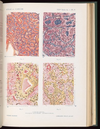
Plate V, Atlas du cancer, J. Darier, 1922-1931.
Association française pour l'étude du cancer- Books
Diseases of the eye / prepared by The Medical Illustration Department, Institute of Ophthalmology, in association with Moorfields Westminster and Central Eye Hospital, London.
Date: February 1955
8 works
- E-books
- Online
A complete body of ancient geography By Mons. D'Anville, Member of the Royal Academy of Belles-Lettres, of the Academy of Sciences at Petersburg, and Secretary to the Great Duke of Orleans. Neatly engraved on thirteen plates. Containing 1. Orbis Romani, pars Orientalis. 2. Orbis Romani, pars Occidentalis. 3. Orbis Veteribus Notus. 4. Gallia. 5. Italiae. 6. Graeciae. 7. Asiae Minor, et Syriae. 8. Palaestina. 9. Aegyptus. 10. Britannia Romana, by Mr. Horsley. 11. Graeciae, pars Septentrionalis. 12. - pars Meridionalis, by Mons. De L'Isle. 13. Germany, France, Italy, Spain, and the British Isles, in an intermediate State, between Ancient and Modern Geography; by Mons. D'Anville. The whole materially improved, by inserting the modern names of places under the ancient.
Anville, Jean Baptiste Bourgignon d' 1697-1782.Date: 1799- E-books
- Online
A general atlas, describing the whole universe Being a complete and new collection of the most approved maps extant ; corrected with the utmost care, and augmented from the latest discoveries, down to 1782. The whole being an improvement of the maps of D'Anville and Robert. Engraved in the best manner on sixty-two copper plates / by Thomas Kitchen, senior, and others.
Kitchin, Thomas d. 1784.Date: 1782- E-books
- Online
A general atlas , describing the whole universe: being a complete collection of the most approved maps extant; corrected with the greatest care, and augmented from the latest discoveries. The whole being an improvement of the maps of D'Anville and Robert. Engraved in the best manner on sixty-two copperplates, by Thomas Kitchen, senior, and others.
Kitchin, Thomas d. 1784.Date: 1794- E-books
- Online
A new system of modern geography or, a geographical historical, and commercial grammar; and present state of the several kingdoms of the world. Containing I. The Figures, Motions, and Distances of the Planets, according to the Newtonian System and the latest Observations. II. A general View of the Earth considered as a Planet; with several useful Geographical Definitions and Problems. III. The grand Divisions of the Globe into Land and Water, Continents and Islands. IV. The Situation and Extent of Empires, Kingdoms, States, Provinces, and Colonies. V. Their Climates, Air, Soil, Vegetable Productions, Metals, Minerals, natural Curiosities, Seas, Rivers, Bays, Capes, Promontories, and Lakes. VI. The Birds and Beasts peculiar to each Country. Vii. Observations on the Changes that have been any where observed upon the Face of Nature since the most early Periods of History. Viii. The History and Origin of Nations; their Forms of Government, Religion, Laws, Revenues, Taxes, Naval and Military Strength. IX. The Genius, Manners, Customs, and Habits of the People. X. Their Language, Learning, Arts, Sciences, Manufactures, and Commerce. XI. The chief Cities, Structures, Ruins, and artificial Curiosities. XII. The Longitude, Latitude, Bearings, and Distances of principal Places from London. To which are added, I. A Geographical Index, with the Names and Places alphabetically arranged. II. A. Table of the Coins of all Nations, and their Value in English Money. III. A Chronological Table of remarkable Events from the Creation to the present Time. By William Guthrie, Esq. The astronomical part by James Ferguson, F.R.S. To which have been added, the late discoveries of Dr. Herschell, and other eminent Astronomers.
Guthrie, William 1708-1770.Date: 1792- E-books
- Online
A complete body of ancient geography . By Mons. D'Anville, Member of the Royal Academy of Belles-Letters, of the Academy of Sciences at Petersburg, and Secretary to the Duke of Oreleans. Containing Orbis Romani pars orientalis. Orbis Romani pars occidentalis. Orbis veteribus notus. Gallia. Italia. Græcia. Asia minor et syria. Palæstina. Ægyptus. To which are added, britannia romana, by Mr. Horsley, &c. Græcæ pars septentrionalis, -pars meridionalis by Mons. Charles De L'Isle. Germany, France, Italy, Spain, and the British Isles, in an intermediate state between ancient and modern geography; by Mons. D'Anville. And the whole improved by inserting the modern names of places under the ancient.
Anville, Jean Baptiste Bourgignon d' 1697-1782.Date: 1785