M0013150: Map of Metlakahtla, Annette Island

Date:
October 1953
Reference:
WT/D/1/20/1/117/78
Part of:
Wellcome Trust Corporate Archive
  • Archives and manuscripts
  • Online

Available online

view M0013150: Map of Metlakahtla, Annette Island

Contains: 1 image

Public Domain Mark

You can use this work for any purpose without restriction under copyright law. Read more about this licence.

Credit

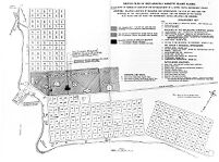
M0013150: Map of Metlakahtla, Annette Island. Public Domain Mark. Source: Wellcome Collection.

About this work

Also known as

Previous title, replaced January 2022: Map of Metlakahtla, Annette Island

Description

Photograph of an illustration of a map of Metlakahtla, Annette Island showing parts claimed by missionaries as part of a legal brief prepared by and on behalf of Henry Wellcome, reproduced from Wellcome, Henry S. (Henry Solomon), Sir: The Story of Metlakahtla, London ; New York : Saxon & Co., 1887. Related images: M0013149, M0013148

Publication/Creation

October 1953

Physical description

1 photograph glass plate negative; 12 x 16.5 cm

Related material

Wellcome Collection holds the publication from which the image depicted in the glass plate negative has been reproduced.

Notes

Catalogue data comes from a combination of entries in the original glass plate registers, metadata created when the glass plates were digitised in the early 2000s and enhancements made by the cataloguer in 2022.

Terms of use

Please consult the digitised version as this item is fragile. Email library@wellcomecollection.org to request access to the physical item.

Where to find it

  • Location Access
    Closed stores
    Can't be requested

    Note

Permanent link